
Geographic Region: USA-COLORADO
Feature: SAN LUIS VALLEY,PIVOT AG
|
Geographic Region: USA-COLORADO Feature: SAN LUIS VALLEY,PIVOT AG |
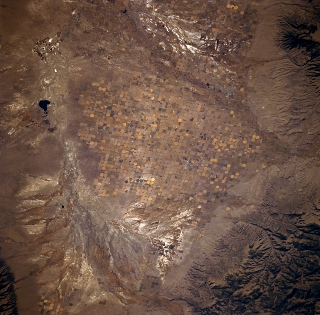 |
| STS073-702-018 San Luis Valley, Colorado, U.S.A. October 1995 Streams that enter the northern half of the San Luis Valley of south-central Colorado, a relatively flat basin, rarely reach the Rio Grande. Despite the fact that the San Luis Valley is a true desert--receiving less than 8 inches of precipitation a year--much of the valley supports a vigorous agricultural industry because of irrigation water from deep artesian wells, some of which tap as many as five or six artesian aquifers. Visible are a large alluvial fan at the northern end of the valley that exhibits the classic pattern found in arid, flat landscapes; San Luis Creek; and San Luis Lake. A smaller, similarly colored drainage feature is also observed at the top center of the photograph. The two highly reflective areas north and south of the cultivated fields are probably the result of accumulations of salt deposited in the soils by the evaporation process. |
| Images: | All Available Images Low-Resolution 346k |
|
| Mission: | STS073 |
|
| Roll - Frame: | 702 - 18 |
|
| Geographical Name: | USA-COLORADO |
|
| Features: | SAN LUIS VALLEY,PIVOT AG |
|
| Center Lat x Lon: | 38.0N x 106W |
|
| Film Exposure: | N | N=Normal exposure, U=Under exposed, O=Over exposed, F=out of Focus |
| Percentage of Cloud Cover-CLDP: | 0 |
|
| Camera:: | HB |
|
| Camera Tilt: | 33 | LO=Low Oblique, HO=High Oblique, NV=Near Vertical |
| Camera Focal Length: | 250 |
|
| Nadir to Photo Center Direction: | N | The direction from the nadir to the center point, N=North, S=South, E=East, W=West |
| Stereo?: | Y | Y=Yes there is an adjacent picture of the same area, N=No there isn't |
| Orbit Number: | 116 |
|
| Date: | 19951027 | YYYYMMDD |
| Time: | 164747 | GMT HHMMSS |
| Nadir Lat: | 36.6N |
Latitude of suborbital point of spacecraft |
| Nadir Lon: | 105.4W |
Longitude of suborbital point of spacecraft |
| Sun Azimuth: | 145 | Clockwise angle in degrees from north to the sun measured at the nadir point |
| Space Craft Altitude: | 143 | nautical miles |
| Sun Elevation: | 34 | Angle in degrees between the horizon and the sun, measured at the nadir point |
| Land Views: | VALLEY, MOUNTAIN |
|
| Water Views: | RIVER |
|
| Atmosphere Views: | |
|
| Man Made Views: | PIVOT IRRIGATION |
|
| City Views: | |
|
Photo is not associated with any sequences | ||
| NASA Home Page |
JSC Home Page |
JSC Digital Image Collection |
Earth Science & Remote Sensing |
|
This service is provided by the International Space Station program and the JSC Earth Science & Remote Sensing Unit, ARES Division, Exploration Integration Science Directorate.

|