
Geographic Region: USA-COLORADO
Feature: CORTEZ,RES.,MOUNTAINS,AG
|
Geographic Region: USA-COLORADO Feature: CORTEZ,RES.,MOUNTAINS,AG |
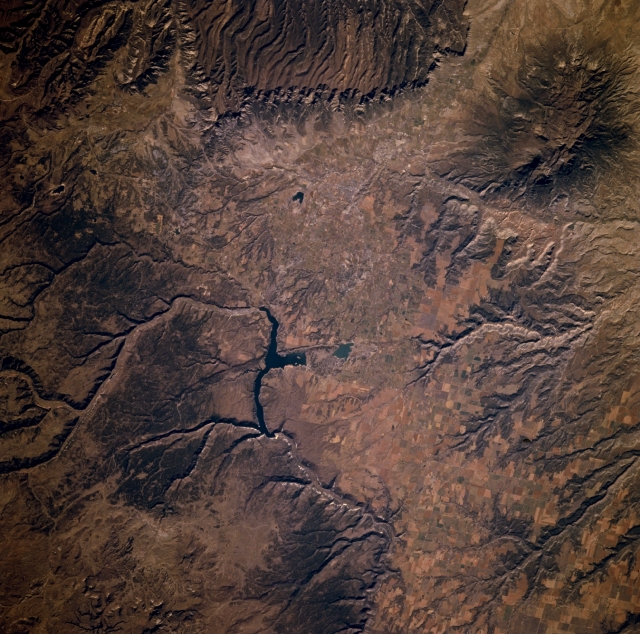 |
| STS073-702-014 Dolores River and Canyon, Colorado, U.S.A. October 1995 Drainage patterns, mesas, and mountains are the prominent landforms in the semiarid environment of extreme southwest Colorado. Apparent are the Dolores River exiting southwest of the mountains and gradually making a U-turn to the northwest. Visible are Sleeping Ute Mountains and Ute Peak [5914 feet (1803 meters) above sea level] (upper right corner) and Mesa Verde National Park, the eroded mesa (top of photograph). Cortez (not discernible) lies near the small, dark, V-shaped reservoir (near top center). |
| Images: | All Available Images Low-Resolution 382k |
|
| Mission: | STS073 |
|
| Roll - Frame: | 702 - 14 |
|
| Geographical Name: | USA-COLORADO |
|
| Features: | CORTEZ,RES.,MOUNTAINS,AG |
|
| Center Lat x Lon: | 37.5N x 108.5W |
|
| Film Exposure: | N | N=Normal exposure, U=Under exposed, O=Over exposed, F=out of Focus |
| Percentage of Cloud Cover-CLDP: | 0 |
|
| Camera:: | HB |
|
| Camera Tilt: | 15 | LO=Low Oblique, HO=High Oblique, NV=Near Vertical |
| Camera Focal Length: | 250 |
|
| Nadir to Photo Center Direction: | NW | The direction from the nadir to the center point, N=North, S=South, E=East, W=West |
| Stereo?: | N | Y=Yes there is an adjacent picture of the same area, N=No there isn't |
| Orbit Number: | 116 |
|
| Date: | 19951027 | YYYYMMDD |
| Time: | 164713 | GMT HHMMSS |
| Nadir Lat: | 37.1N |
Latitude of suborbital point of spacecraft |
| Nadir Lon: | 108W |
Longitude of suborbital point of spacecraft |
| Sun Azimuth: | 142 | Clockwise angle in degrees from north to the sun measured at the nadir point |
| Space Craft Altitude: | 143 | nautical miles |
| Sun Elevation: | 32 | Angle in degrees between the horizon and the sun, measured at the nadir point |
| Land Views: | ESCARPMENT, VALLEY, MOUNTAIN |
|
| Water Views: | RIVER |
|
| Atmosphere Views: | |
|
| Man Made Views: | |
|
| City Views: | |
|
Photo is not associated with any sequences | ||
| NASA Home Page |
JSC Home Page |
JSC Digital Image Collection |
Earth Science & Remote Sensing |
|
This service is provided by the International Space Station program and the JSC Earth Science & Remote Sensing Unit, ARES Division, Exploration Integration Science Directorate.

|