
Geographic Region: KAZAKHSTAN
Feature: LAKE,SALT PANS,CASPIAN S
|
Geographic Region: KAZAKHSTAN Feature: LAKE,SALT PANS,CASPIAN S |
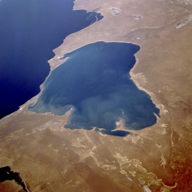 |
| STS073-701-033 Kara-Bogaz Gol and Caspian Sea, Turkmenistan September 1995 An arm of the Caspian Sea (dark blue body of water) and a natural evaporation basin, the lighter blue, water-filled Kara-Bogaz Gol can be seen in this northwest-looking, low-oblique photograph. Because water levels in the Caspian Sea are higher than those in the basin, water flows into the evaporation basin through a dike built in 1979 across the narrow strip of land separating the two bodies of water, and salts are deposited along the basin's shoreline. The elevations of both bodies of water are below sea level, but normally the Caspian Sea is about 10 feet (3 meters) higher than Kara-Bogaz Gol; in the 1980s, however, the water level of the Caspian Sea was approximately the same or slightly lower than that of Kara-Bogaz Gol, causing a lower water level in the basin. Visible in the photograph are a small portion of Krasnovodskiy Bay to the southwest, Kazakhskiy Bay to the northwest, and the western portion of the rugged Ust-Yurt Plateau that extends along the northeast side of Kara-Bogaz Gol. (Refer to photograph STS-51F-040-0064 taken 10 years earlier, which shows very little water in Kara-Bogaz Gol.) |
| Images: | All Available Images Low-Resolution 95k |
|
| Mission: | STS073 |
|
| Roll - Frame: | 701 - 33 |
|
| Geographical Name: | KAZAKHSTAN |
|
| Features: | LAKE,SALT PANS,CASPIAN S |
|
| Center Lat x Lon: | 41.5N x 54.0E |
|
| Film Exposure: | N | N=Normal exposure, U=Under exposed, O=Over exposed, F=out of Focus |
| Percentage of Cloud Cover-CLDP: | 0 |
|
| Camera:: | HB |
|
| Camera Tilt: | 55 | LO=Low Oblique, HO=High Oblique, NV=Near Vertical |
| Camera Focal Length: | 100 |
|
| Nadir to Photo Center Direction: | NW | The direction from the nadir to the center point, N=North, S=South, E=East, W=West |
| Stereo?: | Y | Y=Yes there is an adjacent picture of the same area, N=No there isn't |
| Orbit Number: | 124 |
|
| Date: | 19951028 | YYYYMMDD |
| Time: | 044217 | GMT HHMMSS |
| Nadir Lat: | 38.9N |
Latitude of suborbital point of spacecraft |
| Nadir Lon: | 56.1E |
Longitude of suborbital point of spacecraft |
| Sun Azimuth: | 128 | Clockwise angle in degrees from north to the sun measured at the nadir point |
| Space Craft Altitude: | 142 | nautical miles |
| Sun Elevation: | 21 | Angle in degrees between the horizon and the sun, measured at the nadir point |
| Land Views: | PLAIN, BASIN, COAST, ESCARPMENT |
|
| Water Views: | SEA, LAKE, INLET |
|
| Atmosphere Views: | |
|
| Man Made Views: | |
|
| City Views: | |
|
Associated Photos in Sequence:  Photo #: STS51F-40-64 Photo #: STS51F-40-64Description: TURKMENISTAN, KARA-BOGAZ-GOL--1985; INLET WATER LEVEL INCREASE Sequence ID: 11A  Photo #: STS059-L06-48 Photo #: STS059-L06-48Description: TURKMENISTAN, KARA-BOGAZ-GOL--1994; INLET WATER LEVEL INCREASE Sequence ID: 11B  Photo #: STS073-701-33 ** Currently displayed photo ** Photo #: STS073-701-33 ** Currently displayed photo ** Description: TURKMENISTAN, KARA-BOGAZ-GOL--1995; INLET WATER LEVEL INCREASE Sequence ID: 11C | ||
| NASA Home Page |
JSC Home Page |
JSC Digital Image Collection |
Earth Science & Remote Sensing |
|
This service is provided by the International Space Station program and the JSC Earth Science & Remote Sensing Unit, ARES Division, Exploration Integration Science Directorate.

|