
Geographic Region: VENEZUELA
Feature: PARAGUANA PEN., CORO G.
|
Geographic Region: VENEZUELA Feature: PARAGUANA PEN., CORO G. |
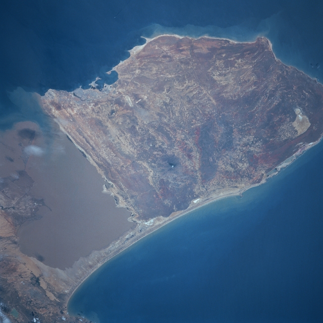 |
| STS070-729-67 Paraguana Peninsula, Venezuela July 1995 The dry, sparsely vegetated, and windswept Paraguana Peninsula is featured in this east-southeast-looking view. Major oil refineries are common along the southwestern coast in the cities of Punta Cardon and Punto Fijo. Numerous sandy beaches dot the north and the eastern coasts. The peninsula is noted as a tourist mecca, offering some of the best windsurfing in the world. Near the center of the view, the rather dark area is the 2723 foot (830 meters) high Mount Santa Ana. Elsewhere the sediment-laden waters of the Gulf of Coro are visible south of the main area of the peninsula, in the right center portion of the image. A small delta extending into the gulf is also visible. Finally, in the upper right portion of the image, the city of Coro can be identified. |
| Images: | All Available Images Low-Resolution 280k |
|
| Mission: | STS070 |
|
| Roll - Frame: | 729 - 67 |
|
| Geographical Name: | VENEZUELA |
|
| Features: | PARAGUANA PEN., CORO G. |
|
| Center Lat x Lon: | 12.0N x 70W |
|
| Film Exposure: | N | N=Normal exposure, U=Under exposed, O=Over exposed, F=out of Focus |
| Percentage of Cloud Cover-CLDP: | 5 |
|
| Camera:: | HB |
|
| Camera Tilt: | 40 | LO=Low Oblique, HO=High Oblique, NV=Near Vertical |
| Camera Focal Length: | 250 |
|
| Nadir to Photo Center Direction: | E | The direction from the nadir to the center point, N=North, S=South, E=East, W=West |
| Stereo?: | N | Y=Yes there is an adjacent picture of the same area, N=No there isn't |
| Orbit Number: | 50 |
|
| Date: | 19950716 | YYYYMMDD |
| Time: | 155418 | GMT HHMMSS |
| Nadir Lat: | 12.2N |
Latitude of suborbital point of spacecraft |
| Nadir Lon: | 72.1W |
Longitude of suborbital point of spacecraft |
| Sun Azimuth: | 55 | Clockwise angle in degrees from north to the sun measured at the nadir point |
| Space Craft Altitude: | 153 | nautical miles |
| Sun Elevation: | 73 | Angle in degrees between the horizon and the sun, measured at the nadir point |
| Land Views: | PENINSULA, DESERT, HILL |
|
| Water Views: | GULF, SEDIMENT, DELTA |
|
| Atmosphere Views: | |
|
| Man Made Views: | URBAN AREA |
|
| City Views: | |
|
Photo is not associated with any sequences | ||
| NASA Home Page |
JSC Home Page |
JSC Digital Image Collection |
Earth Science & Remote Sensing |
|
This service is provided by the International Space Station program and the JSC Earth Science & Remote Sensing Unit, ARES Division, Exploration Integration Science Directorate.

|