
Geographic Region: USA-FLORIDA
Feature: WEST PALM BEACH, ROADS
|
Geographic Region: USA-FLORIDA Feature: WEST PALM BEACH, ROADS |
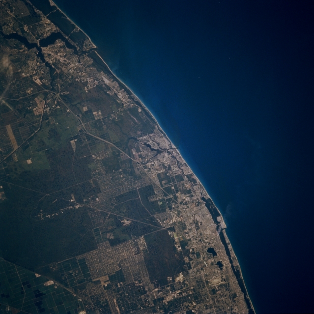 |
| STS070-710-001 East Coast Florida, U.S.A. July 1995 Urban expansion along Florida's east coast from near Stuart in the north to West Palm Beach in the south is easy to identify as lighter, clustered landscape primarily along the shoreline. Darker colors denote nonmetropolitan areas--the water inlet (upper left) with passage through the coastal beaches immediately north of Stuart; the smaller, Y-shaped inlet (near center) at Jupiter; two lakes near the coast adjacent to West Palm Beach; and undeveloped, poorly drained swamplands toward the interior. The light straight and gently curving lines are either canals connecting Lake Okeechobee to coastal east Florida or segments of major highways; e.g., Florida Turnpike, Interstate Highway 95, and U.S. Highway 1. |
| Images: | All Available Images Low-Resolution 277k |
|
| Mission: | STS070 |
|
| Roll - Frame: | 710 - 1 |
|
| Geographical Name: | USA-FLORIDA |
|
| Features: | WEST PALM BEACH, ROADS |
|
| Center Lat x Lon: | 27.0N x 80W |
|
| Film Exposure: | N | N=Normal exposure, U=Under exposed, O=Over exposed, F=out of Focus |
| Percentage of Cloud Cover-CLDP: | 0 |
|
| Camera:: | HB |
|
| Camera Tilt: | 4 | LO=Low Oblique, HO=High Oblique, NV=Near Vertical |
| Camera Focal Length: | 250 |
|
| Nadir to Photo Center Direction: | S | The direction from the nadir to the center point, N=North, S=South, E=East, W=West |
| Stereo?: | Y | Y=Yes there is an adjacent picture of the same area, N=No there isn't |
| Orbit Number: | 64 |
|
| Date: | 19950717 | YYYYMMDD |
| Time: | 124710 | GMT HHMMSS |
| Nadir Lat: | 27.2N |
Latitude of suborbital point of spacecraft |
| Nadir Lon: | 80W |
Longitude of suborbital point of spacecraft |
| Sun Azimuth: | 79 | Clockwise angle in degrees from north to the sun measured at the nadir point |
| Space Craft Altitude: | 157 | nautical miles |
| Sun Elevation: | 27 | Angle in degrees between the horizon and the sun, measured at the nadir point |
| Land Views: | COAST, PLAIN |
|
| Water Views: | OCEAN, CANAL |
|
| Atmosphere Views: | |
|
| Man Made Views: | URBAN AREA, HIGHWAY |
|
| City Views: | |
|
Photo is not associated with any sequences | ||
| NASA Home Page |
JSC Home Page |
JSC Digital Image Collection |
Earth Science & Remote Sensing |
|
This service is provided by the International Space Station program and the JSC Earth Science & Remote Sensing Unit, ARES Division, Exploration Integration Science Directorate.

|