Geographic Region: ALGERIA
Feature: TIFERNINE DUNES, MTS.
|
Geographic Region: ALGERIA Feature: TIFERNINE DUNES, MTS. |
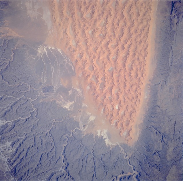 |
| STS070-705-094 Tifernine Dunes, Algeria July 1995 The Tassili N' Ajjer of southeastern Algeria consists of large areas of sand dunes and substantial areas of sandstone bedrock outcrops. This photograph vividly displays the differences between these two major landforms. The orange, complex, linear Tifernine Dunes with superimposed star dunes were named for the intermittently-flowing, south-to-north Tifernine watercourse along the southwestern extent of the dunes. This very distinctive alignment of sand dunes provides Space Shuttle astronauts a land reference in the much larger Sahara Desert. The dark, weathered sandstone rocks that border the Tifernine Dunes to the east and southwest have deep, narrow ravines that comprise a well-entrenched drainage pattern through the higher elevations of the plateau southwest of the dune field. This erosion process began millions of years ago when the climate was much wetter. This region now receives less than 1 inch (2.5 centimeters) of rainfall annually. Tifernine Dunes, central Algeria (north at bottom) The southern half (about 70 miles in this view) of the Tifernine dunes of east-central Algeria appears on this view. The Tifernine dune-sea is one of the more dramatic features visible from the Shuttle when overflying the Sahara Desert. The dunes lie in a basin of dark-colored rocks heavily cut by winding stream courses (top, top right). Very occasional storms allow the streams to erode the dark rocks and transport the sediment to the basin. Westerly winds then mould the stream sediments into the complex dune shapes so well displayed here. |
| Images: | All Available Images Low-Resolution 112k |
|
| Mission: | STS070 |
|
| Roll - Frame: | 705 - 94 |
|
| Geographical Name: | ALGERIA |
|
| Features: | TIFERNINE DUNES, MTS. |
|
| Center Lat x Lon: | 26.5N x 7.0E |
|
| Film Exposure: | N | N=Normal exposure, U=Under exposed, O=Over exposed, F=out of Focus |
| Percentage of Cloud Cover-CLDP: | 0 |
|
| Camera:: | HB |
|
| Camera Tilt: | 22 | LO=Low Oblique, HO=High Oblique, NV=Near Vertical |
| Camera Focal Length: | 250 |
|
| Nadir to Photo Center Direction: | NE | The direction from the nadir to the center point, N=North, S=South, E=East, W=West |
| Stereo?: | Y | Y=Yes there is an adjacent picture of the same area, N=No there isn't |
| Orbit Number: | 45 |
|
| Date: | 19950716 | YYYYMMDD |
| Time: | 081230 | GMT HHMMSS |
| Nadir Lat: | 26.0N |
Latitude of suborbital point of spacecraft |
| Nadir Lon: | 6.1E |
Longitude of suborbital point of spacecraft |
| Sun Azimuth: | 84 | Clockwise angle in degrees from north to the sun measured at the nadir point |
| Space Craft Altitude: | 155 | nautical miles |
| Sun Elevation: | 42 | Angle in degrees between the horizon and the sun, measured at the nadir point |
| Land Views: | DESERT, DUNE, ESCARPMENT, PLATEAU |
|
| Water Views: | |
|
| Atmosphere Views: | |
|
| Man Made Views: | |
|
| City Views: | |
|
Photo is not associated with any sequences | ||
| NASA Home Page |
JSC Home Page |
JSC Digital Image Collection |
Earth Science & Remote Sensing |
|
This service is provided by the International Space Station program and the JSC Earth Science & Remote Sensing Unit, ARES Division, Exploration Integration Science Directorate.

|