Geographic Region: GUYANA
Feature: ESSEQUIBO RIVER DELTA
|
Geographic Region: GUYANA Feature: ESSEQUIBO RIVER DELTA |
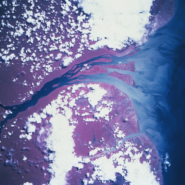 |
| STS069-737-51 Essequibo River, Guyana September 1995 Even though cloud cover obscures approximately fifty percent of the landscape in this image, the delta of the Essequibo River is almost cloud free (near center). The light-colored, streamlining effect at the mouth of the river vividly depicts the sediment pattern and extent of its discharge into the Atlantic Ocean. East of this broad estuary, the smaller sediment plume of the Demerara River is visible as it also empties northward into the Atlantic Ocean (lower right quadrant). Georgetown, Guyana's capital city and chief port, is located along the northeast shore of the larger estuary. Approximately 90 percent of Guyana's estimated 750,000 people live along the agriculturally rich coastal plain. Linear patterns along the coast reflect land ownership boundaries (field boundaries, mainly sugar and cotton plantations) and numerous canals that interconnect the coastal plains. The extensive area of deep red colors inland in this color infrared image shows the tropical rainforest zone that characterizes most of the interior of Guyana. |
| Images: | All Available Images Low-Resolution 355k |
|
| Mission: | STS069 |
|
| Roll - Frame: | 737 - 51 |
|
| Geographical Name: | GUYANA |
|
| Features: | ESSEQUIBO RIVER DELTA |
|
| Center Lat x Lon: | 6.5N x 58.5W |
|
| Film Exposure: | N | N=Normal exposure, U=Under exposed, O=Over exposed, F=out of Focus |
| Percentage of Cloud Cover-CLDP: | 30 |
|
| Camera:: | HB |
|
| Camera Tilt: | 17 | LO=Low Oblique, HO=High Oblique, NV=Near Vertical |
| Camera Focal Length: | 100 |
|
| Nadir to Photo Center Direction: | N | The direction from the nadir to the center point, N=North, S=South, E=East, W=West |
| Stereo?: | Y | Y=Yes there is an adjacent picture of the same area, N=No there isn't |
| Orbit Number: | 95 |
|
| Date: | 19950913 | YYYYMMDD |
| Time: | 154845 | GMT HHMMSS |
| Nadir Lat: | 5.4N |
Latitude of suborbital point of spacecraft |
| Nadir Lon: | 58.4W |
Longitude of suborbital point of spacecraft |
| Sun Azimuth: | 174 | Clockwise angle in degrees from north to the sun measured at the nadir point |
| Space Craft Altitude: | 216 | nautical miles |
| Sun Elevation: | 88 | Angle in degrees between the horizon and the sun, measured at the nadir point |
| Land Views: | COAST |
|
| Water Views: | RIVER, DELTA, SEDIMENT |
|
| Atmosphere Views: | |
|
| Man Made Views: | AGRICULTURE |
|
| City Views: | |
|
Photo is not associated with any sequences | ||
| NASA Home Page |
JSC Home Page |
JSC Digital Image Collection |
Earth Science & Remote Sensing |
|
This service is provided by the International Space Station program and the JSC Earth Science & Remote Sensing Unit, ARES Division, Exploration Integration Science Directorate.

|