Geographic Region: USA-HAWAII
Feature: OAHU, MOUNTAINS, COAST
|
Geographic Region: USA-HAWAII Feature: OAHU, MOUNTAINS, COAST |
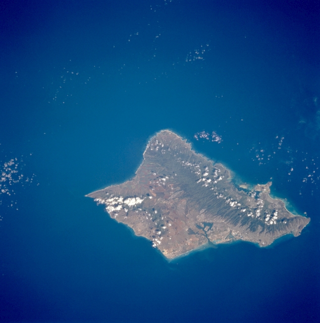 |
| STS069-729-020 Oahu, Hawaii, U.S.A. September 1995 Framed by the dark Pacific Ocean, Oahu appears as an emerald oasis. The green, heavily forested slopes of the Koolau Range on the northeast side of the island are separated from the higher but smaller Waianae Range near the southwest coast by a small, cultivated valley. These three physiographic landforms are aligned in a general northwest-southeast direction. Apparent on the south of Oahu are Honolulu International Airport, Pearl Harbor, Honolulu, and Diamond Head Crater. |
| Images: | Images: | NO IMAGES YET | |||
| Mission: | STS069 |
||||
| Roll - Frame: | 729 - 20 |
||||
| Geographical Name: | USA-HAWAII |
||||
| Features: | OAHU, MOUNTAINS, COAST |
||||
| Center Lat x Lon: | 21.5N x 158W |
||||
| Film Exposure: | N | N=Normal exposure, U=Under exposed, O=Over exposed, F=out of Focus |
|||
| Percentage of Cloud Cover-CLDP: | 5 |
||||
| Camera:: | HB |
||||
| Camera Tilt: | 31 | LO=Low Oblique, HO=High Oblique, NV=Near Vertical |
|||
| Camera Focal Length: | 100 |
||||
| Nadir to Photo Center Direction: | S | The direction from the nadir to the center point, N=North, S=South, E=East, W=West |
|||
| Stereo?: | Y | Y=Yes there is an adjacent picture of the same area, N=No there isn't |
|||
| Orbit Number: | 67 |
||||
| Date: | 19950911 | YYYYMMDD |
|||
| Time: | 203023 | GMT HHMMSS |
|||
| Nadir Lat: | 23.5N |
Latitude of suborbital point of spacecraft | |||
| Nadir Lon: | 157.2W |
Longitude of suborbital point of spacecraft | |||
| Sun Azimuth: | 120 | Clockwise angle in degrees from north to the sun measured at the nadir point |
|||
| Space Craft Altitude: | 215 | nautical miles |
|||
| Sun Elevation: | 56 | Angle in degrees between the horizon and the sun, measured at the nadir point |
|||
| Land Views: | ISLAND, MOUNTAIN, VALLEY |
||||
| Water Views: | |
||||
| Atmosphere Views: | |
||||
| Man Made Views: | URBAN AREA |
||||
| City Views: | |
||||
Photo is not associated with any sequences | |||||
| NASA Home Page |
JSC Home Page |
JSC Digital Image Collection |
Earth Science & Remote Sensing |
|
This service is provided by the International Space Station program and the JSC Earth Science & Remote Sensing Unit, ARES Division, Exploration Integration Science Directorate.

|