Geographic Region: INDONESIA
Feature: SUMBAWA, KOMODO ISLAND
|
Geographic Region: INDONESIA Feature: SUMBAWA, KOMODO ISLAND |
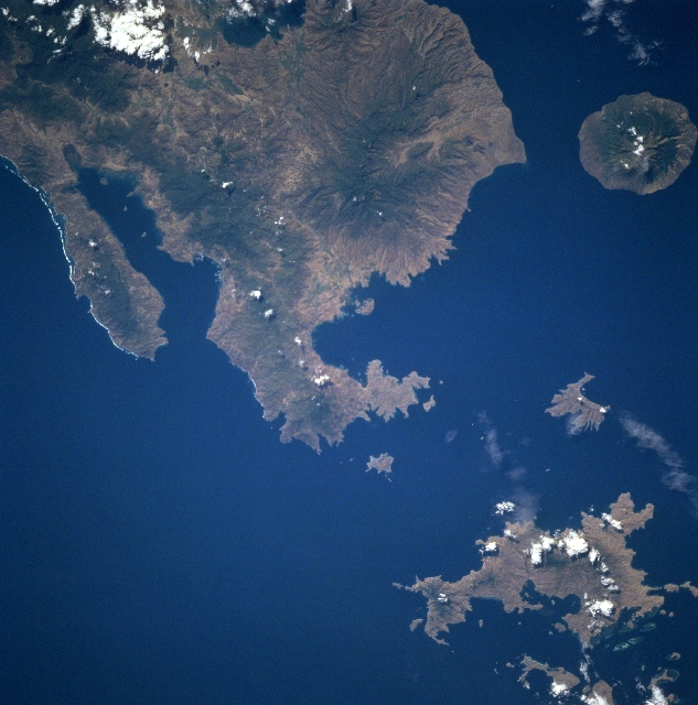 |
| STS069-721-091 Sumbawa, Komodo, and Sangeang Islands, Indonesia September 1995 Several volcanic islands in the Indonesian Archipelago are visible in this near-nadir view. The eastern end of Sumbawa Island (top center), Sangeang Island (small, oval-shaped in the upper right) and Komodo Island (irregular-shaped coastline in the bottom right) are the most prominent. Sumbawa Island has many volcanic peaks, including the dormant Gunung Daria located to the right midway between the center and upper center of the image. The slopes of the volcanoes and other mountains are forest-covered. The soils of the island are very fertile. Tropical fruit and rice are grown. To the north-northeast of Sumbawa near the upper right portion of the image is the 8-mile (13 km) wide Sangeang Island and one of the more active stratovolcano's in Indonesia, Api. The volcano is actually made up of two volcanic peaks, the highest at 6293 feet (1949 meters) and the other at 5888 feet (1795 meters). Api has been very active throughout the 20th Century. Just to the east of Sumbawa Island is the Sapa Strait. Near the bottom right of the image is Komodo Island. The island, which is very wild and rugged, is 25 miles (40 km) long and 12 miles (19 km) wide and is home to the world famous Komodo Dragon, one of the largest reptiles in the world. The Sumba Strait covers the bottom left portion of the image. |
| Images: | All Available Images Low-Resolution 327k |
|
| Mission: | STS069 |
|
| Roll - Frame: | 721 - 91 |
|
| Geographical Name: | INDONESIA |
|
| Features: | SUMBAWA, KOMODO ISLAND |
|
| Center Lat x Lon: | 8.5S x 119.0E |
|
| Film Exposure: | N | N=Normal exposure, U=Under exposed, O=Over exposed, F=out of Focus |
| Percentage of Cloud Cover-CLDP: | 10 |
|
| Camera:: | HB |
|
| Camera Tilt: | 19 | LO=Low Oblique, HO=High Oblique, NV=Near Vertical |
| Camera Focal Length: | 100 |
|
| Nadir to Photo Center Direction: | SE | The direction from the nadir to the center point, N=North, S=South, E=East, W=West |
| Stereo?: | Y | Y=Yes there is an adjacent picture of the same area, N=No there isn't |
| Orbit Number: | 58 |
|
| Date: | 19950911 | YYYYMMDD |
| Time: | 065736 | GMT HHMMSS |
| Nadir Lat: | 7.8S |
Latitude of suborbital point of spacecraft |
| Nadir Lon: | 118.0E |
Longitude of suborbital point of spacecraft |
| Sun Azimuth: | 285 | Clockwise angle in degrees from north to the sun measured at the nadir point |
| Space Craft Altitude: | 215 | nautical miles |
| Sun Elevation: | 45 | Angle in degrees between the horizon and the sun, measured at the nadir point |
| Land Views: | ISLAND, VOLCANO, FOREST |
|
| Water Views: | BAY, STRAIT |
|
| Atmosphere Views: | |
|
| Man Made Views: | |
|
| City Views: | |
|
Photo is not associated with any sequences | ||
| NASA Home Page |
JSC Home Page |
JSC Digital Image Collection |
Earth Science & Remote Sensing |
|
This service is provided by the International Space Station program and the JSC Earth Science & Remote Sensing Unit, ARES Division, Exploration Integration Science Directorate.

|