
Geographic Region: AUSTRALIA
Feature: SANDY ISLET, REEFS
|
Geographic Region: AUSTRALIA Feature: SANDY ISLET, REEFS |
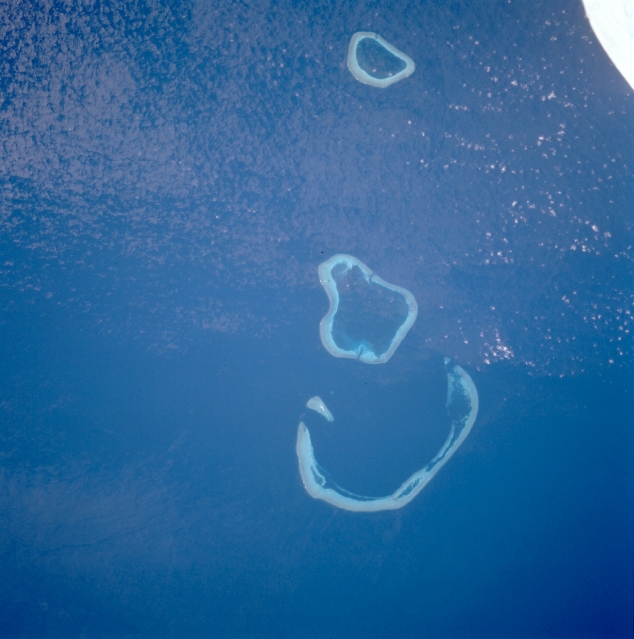 |
| STS069-716-028 Seringgapatam and Scott Reefs, Australia September 1995 The three large, round submarine structures (light blue) are reefs located off the north coast of Western Australia. Seringapatam Reef is the smaller reef at top center of the image, and the other reefs comprise Scott Reef. The small white object in the upper right corner of the image is part of the Space Shuttle. |
| Images: | All Available Images Low-Resolution 277k |
|
| Mission: | STS069 |
|
| Roll - Frame: | 716 - 28 |
|
| Geographical Name: | AUSTRALIA |
|
| Features: | SANDY ISLET, REEFS |
|
| Center Lat x Lon: | 14S x 122.0E |
|
| Film Exposure: | N | N=Normal exposure, U=Under exposed, O=Over exposed, F=out of Focus |
| Percentage of Cloud Cover-CLDP: | 5 |
|
| Camera:: | HB |
|
| Camera Tilt: | 11 | LO=Low Oblique, HO=High Oblique, NV=Near Vertical |
| Camera Focal Length: | 100 |
|
| Nadir to Photo Center Direction: | SW | The direction from the nadir to the center point, N=North, S=South, E=East, W=West |
| Stereo?: | N | Y=Yes there is an adjacent picture of the same area, N=No there isn't |
| Orbit Number: | 104 |
|
| Date: | 19950914 | YYYYMMDD |
| Time: | 055033 | GMT HHMMSS |
| Nadir Lat: | 13.5S |
Latitude of suborbital point of spacecraft |
| Nadir Lon: | 122.5E |
Longitude of suborbital point of spacecraft |
| Sun Azimuth: | 297 | Clockwise angle in degrees from north to the sun measured at the nadir point |
| Space Craft Altitude: | 216 | nautical miles |
| Sun Elevation: | 55 | Angle in degrees between the horizon and the sun, measured at the nadir point |
| Land Views: | |
|
| Water Views: | OCEAN, REEF |
|
| Atmosphere Views: | |
|
| Man Made Views: | |
|
| City Views: | |
|
Photo is not associated with any sequences | ||
| NASA Home Page |
JSC Home Page |
JSC Digital Image Collection |
Earth Science & Remote Sensing |
|
This service is provided by the International Space Station program and the JSC Earth Science & Remote Sensing Unit, ARES Division, Exploration Integration Science Directorate.

|