Geographic Region: ETHIOPIA
Feature: LAKE RUDOLF, MTS., DES.
|
Geographic Region: ETHIOPIA Feature: LAKE RUDOLF, MTS., DES. |
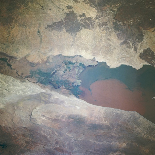 |
| STS069-713-090 Omo River Delta and Lake Rudolf, Ethiopia and Kenya August 1995 This east-looking, low-oblique photograph exhibits the delta of the sediment-laden Omo River as it continues to expand southward into Lake Turkana (Lake Rudolf) in northern Kenya. The Omo River, with its headwaters in the highlands of Ethiopia, is 400 miles (644 kilometers) long and has been dumping vast amounts of sediment into Lake Turkana since the late 1950s. The delta has expanded from the northern end of the lake to its present position (center of the photograph) in less than 40 years. The increased sediment is caused by deforestation along most of the watercourse. Located in the Great Rift Valley of eastern Africa, Lake Turkana, 154 miles (248 kilometers) long and approximately 20 miles (32 kilometers) wide, is surrounded by volcanoes. The lake has no natural outlet, and despite the great influx of fresh water from the Omo River, it is becoming more saline each year. A small island, the remnant of an old volcanic peak, is visible south of the delta. |
| Images: | All Available Images Low-Resolution 110k |
|
| Mission: | STS069 |
|
| Roll - Frame: | 713 - 90 |
|
| Geographical Name: | ETHIOPIA |
|
| Features: | LAKE RUDOLF, MTS., DES. |
|
| Center Lat x Lon: | 4.5N x 36.0E |
|
| Film Exposure: | N | N=Normal exposure, U=Under exposed, O=Over exposed, F=out of Focus |
| Percentage of Cloud Cover-CLDP: | 0 |
|
| Camera:: | HB |
|
| Camera Tilt: | 36 | LO=Low Oblique, HO=High Oblique, NV=Near Vertical |
| Camera Focal Length: | 100 |
|
| Nadir to Photo Center Direction: | W | The direction from the nadir to the center point, N=North, S=South, E=East, W=West |
| Stereo?: | N | Y=Yes there is an adjacent picture of the same area, N=No there isn't |
| Orbit Number: | 137 |
|
| Date: | 19950916 | YYYYMMDD |
| Time: | 075839 | GMT HHMMSS |
| Nadir Lat: | 4.8N |
Latitude of suborbital point of spacecraft |
| Nadir Lon: | 38.2E |
Longitude of suborbital point of spacecraft |
| Sun Azimuth: | 95 | Clockwise angle in degrees from north to the sun measured at the nadir point |
| Space Craft Altitude: | 185 | nautical miles |
| Sun Elevation: | 69 | Angle in degrees between the horizon and the sun, measured at the nadir point |
| Land Views: | PLATEAU, VALLEY |
|
| Water Views: | RIVER, DELTA, LAKE, SEDIMENT |
|
| Atmosphere Views: | |
|
| Man Made Views: | |
|
| City Views: | |
|
Photo is not associated with any sequences | ||
| NASA Home Page |
JSC Home Page |
JSC Digital Image Collection |
Earth Science & Remote Sensing |
|
This service is provided by the International Space Station program and the JSC Earth Science & Remote Sensing Unit, ARES Division, Exploration Integration Science Directorate.

|