
Geographic Region: SOMALIA
Feature: HAFUN, COAST, SUNGLINT
|
Geographic Region: SOMALIA Feature: HAFUN, COAST, SUNGLINT |
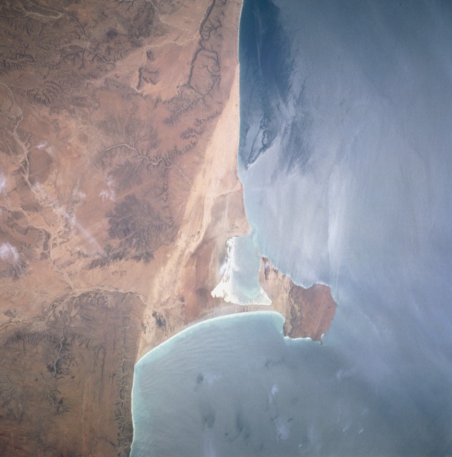 |
| STS-069-711-0AG Hafun Peninsula, Northeast Somalia August 1995 The Hafun Peninsula along the northeast coast of Somalia is a tombolo -- a long, narrow accumulation of sand with one end attached to the mainland and the other end projecting to an offshore island or pillar of rocks. This part of Somalia is a hot desert with very little vegetation. Vivid drainage patterns are visible adjacent to the coastal sands. This natural color photograph and color infrared STS-049-087-035 may be compared--the color infrared photograph uses sunglint to show dynamic ocean patterns; however, this natural color picture also shows ocean dynamics as the warm, north-flowing current has produced an "island" wake effect on the north side of the peninsula. It is also interesting to compare the north-south-oriented lines of color change in the area immediately west of the tombolo, a change possibly resulting from the beach sands meeting a more resistant low escarpment that has different reflective properties. |
| Images: | All Available Images Low-Resolution 87k |
|
| Mission: | STS069 |
|
| Roll - Frame: | 711 - AG |
|
| Geographical Name: | SOMALIA |
|
| Features: | HAFUN, COAST, SUNGLINT |
|
| Center Lat x Lon: | 10.5N x 51.0E |
|
| Film Exposure: | N | N=Normal exposure, U=Under exposed, O=Over exposed, F=out of Focus |
| Percentage of Cloud Cover-CLDP: | 0 |
|
| Camera:: | HB |
|
| Camera Tilt: | LO | LO=Low Oblique, HO=High Oblique, NV=Near Vertical |
| Camera Focal Length: | 100 |
|
| Nadir to Photo Center Direction: | The direction from the nadir to the center point, N=North, S=South, E=East, W=West |
|
| Stereo?: | N | Y=Yes there is an adjacent picture of the same area, N=No there isn't |
| Orbit Number: | |
|
| Date: | 199509__ | YYYYMMDD |
| Time: | GMT HHMMSS |
|
| Nadir Lat: | N |
Latitude of suborbital point of spacecraft |
| Nadir Lon: | E |
Longitude of suborbital point of spacecraft |
| Sun Azimuth: | Clockwise angle in degrees from north to the sun measured at the nadir point |
|
| Space Craft Altitude: | nautical miles |
|
| Sun Elevation: | Angle in degrees between the horizon and the sun, measured at the nadir point |
|
| Land Views: | PENINSULA |
|
| Water Views: | OCEAN |
|
| Atmosphere Views: | |
|
| Man Made Views: | |
|
| City Views: | |
|
Photo is not associated with any sequences | ||
| NASA Home Page |
JSC Home Page |
JSC Digital Image Collection |
Earth Science & Remote Sensing |
|
This service is provided by the International Space Station program and the JSC Earth Science & Remote Sensing Unit, ARES Division, Exploration Integration Science Directorate.

|