
Geographic Region: USA-OREGON
Feature: COAST NEAR CRESCENT CITY
|
Geographic Region: USA-OREGON Feature: COAST NEAR CRESCENT CITY |
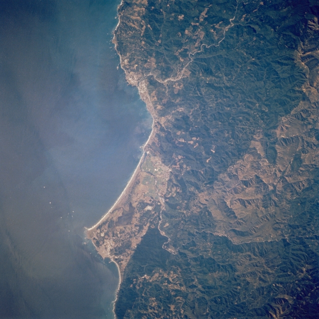 |
| STS068-273-039 Crescent City and Smith River, California, U.S.A. October 1994 This near-vertical photograph shows the Smith River winding across a small coastal plain before emptying into the Pacific Ocean. Some clear-cutting is visible in the forested Klamath Mountains east of the Pacific Ocean. Along the coast and south of the Smith River mouth is Lake Earl. To the lake's south lie Point Saint George and to the southeast Crescent City. The green forested areas east and south of Crescent City are parts of Redwood National Park. The Chetco River winds its way southwestward to its mouth near Brookings, Oregon. |
| Images: | All Available Images Low-Resolution 331k |
|
| Mission: | STS068 |
|
| Roll - Frame: | 273 - 39 |
|
| Geographical Name: | USA-OREGON |
|
| Features: | COAST NEAR CRESCENT CITY |
|
| Center Lat x Lon: | 42.0N x 124W |
|
| Film Exposure: | N | N=Normal exposure, U=Under exposed, O=Over exposed, F=out of Focus |
| Percentage of Cloud Cover-CLDP: | 0 |
|
| Camera:: | HB |
|
| Camera Tilt: | 30 | LO=Low Oblique, HO=High Oblique, NV=Near Vertical |
| Camera Focal Length: | 250 |
|
| Nadir to Photo Center Direction: | SE | The direction from the nadir to the center point, N=North, S=South, E=East, W=West |
| Stereo?: | N | Y=Yes there is an adjacent picture of the same area, N=No there isn't |
| Orbit Number: | 56 |
|
| Date: | 19941003 | YYYYMMDD |
| Time: | 210944 | GMT HHMMSS |
| Nadir Lat: | 42.8N |
Latitude of suborbital point of spacecraft |
| Nadir Lon: | 124.8W |
Longitude of suborbital point of spacecraft |
| Sun Azimuth: | 201 | Clockwise angle in degrees from north to the sun measured at the nadir point |
| Space Craft Altitude: | 117 | nautical miles |
| Sun Elevation: | 41 | Angle in degrees between the horizon and the sun, measured at the nadir point |
| Land Views: | MOUNTAIN, FOREST, COAST, CAPE |
|
| Water Views: | SEDIMENT |
|
| Atmosphere Views: | |
|
| Man Made Views: | URBAN AREA |
|
| City Views: | BROOKINGS, CRESCENT CITY |
|
Photo is not associated with any sequences | ||
| NASA Home Page |
JSC Home Page |
JSC Digital Image Collection |
Earth Science & Remote Sensing |
|
This service is provided by the International Space Station program and the JSC Earth Science & Remote Sensing Unit, ARES Division, Exploration Integration Science Directorate.

|