
Geographic Region: USA-OREGON
Feature: CAPE BLANCO
|
Geographic Region: USA-OREGON Feature: CAPE BLANCO |
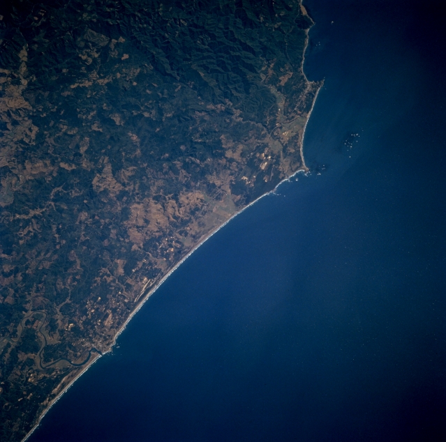 |
| STS068-273-038 Cape Blanco, Oregon, U.S.A. October 1994 Cape Blanco, the westernmost point in the contiguous United States, is featured in this low-oblique, south-southeasterly-looking photograph. Known as one of the windiest places in the western United States, Cape Blanco has registered winds of 184 miles (296 kilometers) an hour. Barely discernible north and west of the cape is a small, rocky arc. Visible are the forest-covered Coast Ranges and the Coquille River as it enters the Pacific Ocean. |
| Images: | All Available Images Low-Resolution 289k |
|
| Mission: | STS068 |
|
| Roll - Frame: | 273 - 38 |
|
| Geographical Name: | USA-OREGON |
|
| Features: | CAPE BLANCO |
|
| Center Lat x Lon: | 43.0N x 124.5W |
|
| Film Exposure: | N | N=Normal exposure, U=Under exposed, O=Over exposed, F=out of Focus |
| Percentage of Cloud Cover-CLDP: | 0 |
|
| Camera:: | HB |
|
| Camera Tilt: | 31 | LO=Low Oblique, HO=High Oblique, NV=Near Vertical |
| Camera Focal Length: | 250 |
|
| Nadir to Photo Center Direction: | E | The direction from the nadir to the center point, N=North, S=South, E=East, W=West |
| Stereo?: | N | Y=Yes there is an adjacent picture of the same area, N=No there isn't |
| Orbit Number: | 56 |
|
| Date: | 19941003 | YYYYMMDD |
| Time: | 210931 | GMT HHMMSS |
| Nadir Lat: | 43.4N |
Latitude of suborbital point of spacecraft |
| Nadir Lon: | 125.6W |
Longitude of suborbital point of spacecraft |
| Sun Azimuth: | 199 | Clockwise angle in degrees from north to the sun measured at the nadir point |
| Space Craft Altitude: | 117 | nautical miles |
| Sun Elevation: | 41 | Angle in degrees between the horizon and the sun, measured at the nadir point |
| Land Views: | CAPE, COAST, MOUNTAIN, FOREST |
|
| Water Views: | |
|
| Atmosphere Views: | |
|
| Man Made Views: | |
|
| City Views: | |
|
Photo is not associated with any sequences | ||
| NASA Home Page |
JSC Home Page |
JSC Digital Image Collection |
Earth Science & Remote Sensing |
|
This service is provided by the International Space Station program and the JSC Earth Science & Remote Sensing Unit, ARES Division, Exploration Integration Science Directorate.

|