Geographic Region: RUSSIAN FEDERATION
Feature: KAMCHATKA PEN. VOLCANOES
|
Geographic Region: RUSSIAN FEDERATION Feature: KAMCHATKA PEN. VOLCANOES |
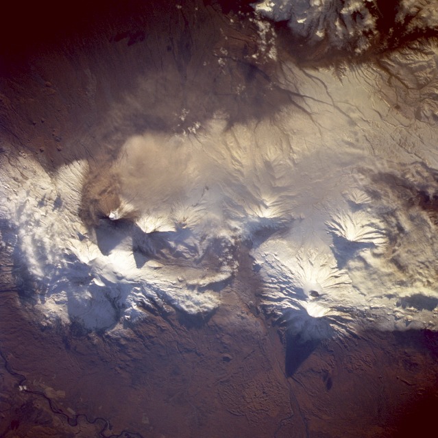 |
| STS068-273-033 Klyuchevskaya Volcano, Kamchatka Peninsula, Russia October 1994 Klyuchevskaya Volcano erupted with lava and ash explosions only 2 days before this near-vertical photograph was taken October 3, 1994. The landscape does not appear to have been much affected by the large quantity of ash that was spewed into the atmosphere. Collateral information obtained from the Smithsonian Institution Global Volcanism Network indicated that the eruption was still in progress at the time this photograph was taken but, obviously, at a greatly reduced rate compared to the earlier eruption in which the gas and steam plume rose to an estimated height of 0.6 mile (1 kilometer) above the crater and was dispersed to the south for approximately 3 miles (5 kilometers). Lengthy shadows are cast from several adjacent stratovolcanoes. The summit of Tolbachinskiy Volcano at 12 080 feet (3680 meters) above sea level is prominent southwest of Klyuchevskaya. A small segment of the meandering Kamchatka River is visible along the northwestern edge of the photograph. (Refer to STS-068-214-043 for an oblique view of the erupting volcano on October 1, 1994.) |
| Images: | All Available Images Low-Resolution 118k |
|
| Mission: | STS068 |
|
| Roll - Frame: | 273 - 33 |
|
| Geographical Name: | RUSSIAN FEDERATION |
|
| Features: | KAMCHATKA PEN. VOLCANOES |
|
| Center Lat x Lon: | 56.0N x 161.0E |
|
| Film Exposure: | N | N=Normal exposure, U=Under exposed, O=Over exposed, F=out of Focus |
| Percentage of Cloud Cover-CLDP: | 5 |
|
| Camera:: | HB |
|
| Camera Tilt: | 51 | LO=Low Oblique, HO=High Oblique, NV=Near Vertical |
| Camera Focal Length: | 250 |
|
| Nadir to Photo Center Direction: | W | The direction from the nadir to the center point, N=North, S=South, E=East, W=West |
| Stereo?: | N | Y=Yes there is an adjacent picture of the same area, N=No there isn't |
| Orbit Number: | 56 |
|
| Date: | 19941003 | YYYYMMDD |
| Time: | 205747 | GMT HHMMSS |
| Nadir Lat: | 55.2N |
Latitude of suborbital point of spacecraft |
| Nadir Lon: | 163.2E |
Longitude of suborbital point of spacecraft |
| Sun Azimuth: | 118 | Clockwise angle in degrees from north to the sun measured at the nadir point |
| Space Craft Altitude: | 116 | nautical miles |
| Sun Elevation: | 13 | Angle in degrees between the horizon and the sun, measured at the nadir point |
| Land Views: | VOLCANO, MOUNTAIN, VALLEY |
|
| Water Views: | RIVER |
|
| Atmosphere Views: | |
|
| Man Made Views: | |
|
| City Views: | |
|
Photo is not associated with any sequences | ||
| NASA Home Page |
JSC Home Page |
JSC Digital Image Collection |
Earth Science & Remote Sensing |
|
This service is provided by the International Space Station program and the JSC Earth Science & Remote Sensing Unit, ARES Division, Exploration Integration Science Directorate.

|