Geographic Region: RUSSIAN FEDERATION
Feature: CITY OF SVERDLOVSK,LAKES
|
Geographic Region: RUSSIAN FEDERATION Feature: CITY OF SVERDLOVSK,LAKES |
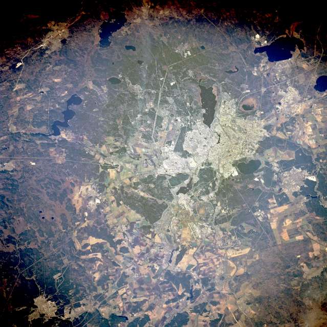 |
| STS068-269-004 Yekaterinburg (Sverdlovsk) Russia October 1994 The Russian city of Yekaterinburg (Sverdlovsk), with more than 1 million people on the eastern flank of the Ural Mountains, is a regional service center for the wide range of minerals extracted from the Urals. Linear features radiate in all directions from the city--railroads; highways; pipelines; dual runways of a large airport southeast of the city; and power line rights-of-way, especially in the wide swath southwest of the city. Yekaterinburg serves as the western terminus for the Trans-Siberian Railroad. Visible are two smaller cities--Verkhnyaya Pyshma and Berezovskiy--north and northeast, respectively, and numerous lakes. The region (latitude 57 degrees north) has a relatively short growing season; however, cultivated field patterns are discernible in the area. |
| Images: | All Available Images Low-Resolution 68k |
|
| Mission: | STS068 |
|
| Roll - Frame: | 269 - 4 |
|
| Geographical Name: | RUSSIAN FEDERATION |
|
| Features: | CITY OF SVERDLOVSK,LAKES |
|
| Center Lat x Lon: | 57.0N x 60.5E |
|
| Film Exposure: | N | N=Normal exposure, U=Under exposed, O=Over exposed, F=out of Focus |
| Percentage of Cloud Cover-CLDP: | 0 |
|
| Camera:: | HB |
|
| Camera Tilt: | 43 | LO=Low Oblique, HO=High Oblique, NV=Near Vertical |
| Camera Focal Length: | 250 |
|
| Nadir to Photo Center Direction: | W | The direction from the nadir to the center point, N=North, S=South, E=East, W=West |
| Stereo?: | N | Y=Yes there is an adjacent picture of the same area, N=No there isn't |
| Orbit Number: | 62 |
|
| Date: | 19941004 | YYYYMMDD |
| Time: | 055530 | GMT HHMMSS |
| Nadir Lat: | 56.4N |
Latitude of suborbital point of spacecraft |
| Nadir Lon: | 62.2E |
Longitude of suborbital point of spacecraft |
| Sun Azimuth: | 151 | Clockwise angle in degrees from north to the sun measured at the nadir point |
| Space Craft Altitude: | 117 | nautical miles |
| Sun Elevation: | 26 | Angle in degrees between the horizon and the sun, measured at the nadir point |
| Land Views: | PLAIN, FOREST, HILL |
|
| Water Views: | LAKE, RIVER |
|
| Atmosphere Views: | |
|
| Man Made Views: | URBAN AREA, AIRPORT, AGRICULTURE |
|
| City Views: | SVERDLOVSK |
|
Photo is not associated with any sequences | ||
| NASA Home Page |
JSC Home Page |
JSC Digital Image Collection |
Earth Science & Remote Sensing |
|
This service is provided by the International Space Station program and the JSC Earth Science & Remote Sensing Unit, ARES Division, Exploration Integration Science Directorate.

|