
Geographic Region: USA-MARYLAND
Feature: CHESAPEAKE, DELAWARE BAY
|
Geographic Region: USA-MARYLAND Feature: CHESAPEAKE, DELAWARE BAY |
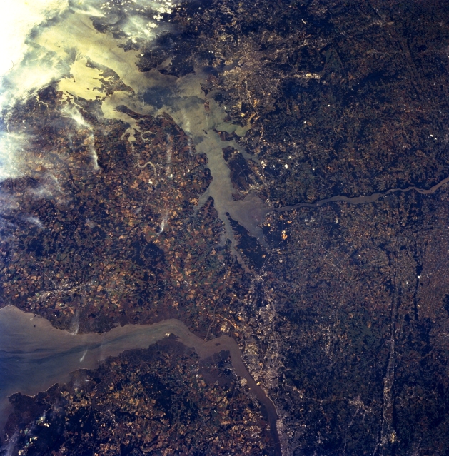 |
| STS068-264-006 Delaware And Upper Chesapeake Bays, Maryland, U.S.A. October 1994 Delaware and upper Chesapeake Bays can be seen in this southwest-looking, low-oblique view. The Susquehanna River enters the scene near right of center (northwest) and flows into Chesapeake Bay (center of the image). The sediment-laden Delaware River enters the scene at the bottom center of the image and flows past Wilmington, Delaware (western shore). The river then turns southeastward into Delaware Bay, an estuary 52 miles (84 km) long, located between the states of New Jersey (bottom left) and Delaware (left center). The Chesapeake and Delaware Canal, part of the Intracoastal Waterway, which connects the Delaware River with the Chesapeake Bay, is barely discernible to the south of Wilmington. Wilmington is a port of entry handling considerable domestic and foreign shipping. The city has vast shipyards and is a large chemical industrial center. Towards the top of the image is the city of Baltimore. |
| Images: | All Available Images Low-Resolution 397k |
|
| Mission: | STS068 |
|
| Roll - Frame: | 264 - 6 |
|
| Geographical Name: | USA-MARYLAND |
|
| Features: | CHESAPEAKE, DELAWARE BAY |
|
| Center Lat x Lon: | 39.5N x 76W |
|
| Film Exposure: | N | N=Normal exposure, U=Under exposed, O=Over exposed, F=out of Focus |
| Percentage of Cloud Cover-CLDP: | 10 |
|
| Camera:: | HB |
|
| Camera Tilt: | 31 | LO=Low Oblique, HO=High Oblique, NV=Near Vertical |
| Camera Focal Length: | 100 |
|
| Nadir to Photo Center Direction: | W | The direction from the nadir to the center point, N=North, S=South, E=East, W=West |
| Stereo?: | N | Y=Yes there is an adjacent picture of the same area, N=No there isn't |
| Orbit Number: | 38 |
|
| Date: | 19941002 | YYYYMMDD |
| Time: | 183206 | GMT HHMMSS |
| Nadir Lat: | 39.9N |
Latitude of suborbital point of spacecraft |
| Nadir Lon: | 74.9W |
Longitude of suborbital point of spacecraft |
| Sun Azimuth: | 215 | Clockwise angle in degrees from north to the sun measured at the nadir point |
| Space Craft Altitude: | 118 | nautical miles |
| Sun Elevation: | 41 | Angle in degrees between the horizon and the sun, measured at the nadir point |
| Land Views: | COAST, PLAIN |
|
| Water Views: | BAY, SEDIMENT, SUNGLINT, RIVER |
|
| Atmosphere Views: | |
|
| Man Made Views: | URBAN AREA |
|
| City Views: | |
|
Photo is not associated with any sequences | ||
| NASA Home Page |
JSC Home Page |
JSC Digital Image Collection |
Earth Science & Remote Sensing |
|
This service is provided by the International Space Station program and the JSC Earth Science & Remote Sensing Unit, ARES Division, Exploration Integration Science Directorate.

|