
Geographic Region: USA-WASHINGTON
Feature: COLUMBIA R., KELSO
|
Geographic Region: USA-WASHINGTON Feature: COLUMBIA R., KELSO |
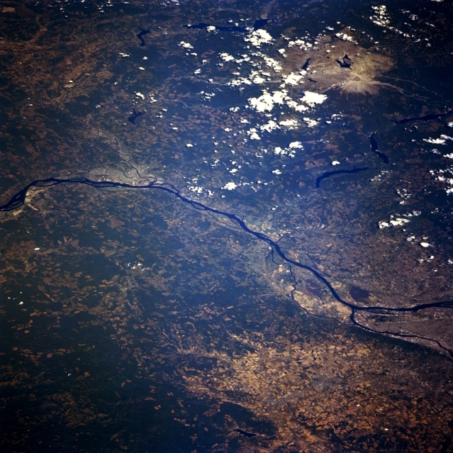 |
| STS068-262-025 Columbia River, Oregon and Washington, U.S.A. October 1994 This north-northeast-looking, low-oblique photograph features the Columbia River crossing from Astoria (near the left center) to Portland, Oregon (just below the right center). After passing through the gorge, the Columbia River from Portland to its mouth can accommodate ocean-going vessels. West of Portland, numerous agricultural field patterns are visible. Mount Saint Helens Volcano and its blast zone from the May 1980 eruption appear light gray near the top right of the photograph. Longview and Kelso, Washington, are discernible near the left center of the photograph. The Coast Range is apparent at the left edge. |
| Images: | All Available Images Low-Resolution 388k |
|
| Mission: | STS068 |
|
| Roll - Frame: | 262 - 25 |
|
| Geographical Name: | USA-WASHINGTON |
|
| Features: | COLUMBIA R., KELSO |
|
| Center Lat x Lon: | 46.0N x 122.5W |
|
| Film Exposure: | N | N=Normal exposure, U=Under exposed, O=Over exposed, F=out of Focus |
| Percentage of Cloud Cover-CLDP: | 10 |
|
| Camera:: | HB |
|
| Camera Tilt: | LO | LO=Low Oblique, HO=High Oblique, NV=Near Vertical |
| Camera Focal Length: | 250 |
|
| Nadir to Photo Center Direction: | NE | The direction from the nadir to the center point, N=North, S=South, E=East, W=West |
| Stereo?: | Y | Y=Yes there is an adjacent picture of the same area, N=No there isn't |
| Orbit Number: | 40 |
|
| Date: | 19941002 | YYYYMMDD |
| Time: | 212823 | GMT HHMMSS |
| Nadir Lat: | 43.7N |
Latitude of suborbital point of spacecraft |
| Nadir Lon: | 125.1W |
Longitude of suborbital point of spacecraft |
| Sun Azimuth: | 206 | Clockwise angle in degrees from north to the sun measured at the nadir point |
| Space Craft Altitude: | 117 | nautical miles |
| Sun Elevation: | 40 | Angle in degrees between the horizon and the sun, measured at the nadir point |
| Land Views: | VOLCANO, FOREST |
|
| Water Views: | RIVER |
|
| Atmosphere Views: | |
|
| Man Made Views: | URBAN AREA, AGRICULTURE |
|
| City Views: | |
|
Photo is not associated with any sequences | ||
| NASA Home Page |
JSC Home Page |
JSC Digital Image Collection |
Earth Science & Remote Sensing |
|
This service is provided by the International Space Station program and the JSC Earth Science & Remote Sensing Unit, ARES Division, Exploration Integration Science Directorate.

|