Geographic Region: SOCIETY ISLANDS
Feature: UTUROA,BORA-BORA ISLANDS
|
Geographic Region: SOCIETY ISLANDS Feature: UTUROA,BORA-BORA ISLANDS |
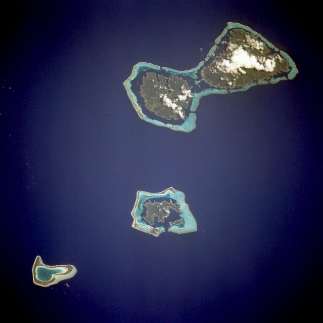 |
| STS068-258-042 Bora-Bora, Society Islands, French Polynesia October 1994 Considered by many as one of the natural wonders of the world, the island of Bora-Bora is a single island surrounded by an extensive coral reef and a beautiful blue lagoon captured in the center of this low-oblique photograph. Like most of its neighboring islands, Bora-Bora, a remnant of a severely eroded, exposed tip of an extinct volcano, is one of the volcanic Society Islands, part of French Polynesia. The coral reef north of Bora-Bora is Tupai Atoll. The two islands southeast of Bora-Bora--Tahaa (northern island) and Raiatea (larger southern island)--are encircled by a single coral reef system. These three islands and atoll represent an excellent teaching tool to explain the evolutionary physical cycle, which requires thousands of years, through which these volcanic islands pass. Three types of coral reefs--fringing reefs, barrier reefs, and atolls--develop in sequence around the south Pacific volcanic islands. Similarly, the volcanic islands are born and erode until no land or inner islands exist, and only the coral atolls remain. |
| Images: | All Available Images Low-Resolution 72k |
|
| Mission: | STS068 |
|
| Roll - Frame: | 258 - 42 |
|
| Geographical Name: | SOCIETY ISLANDS |
|
| Features: | UTUROA,BORA-BORA ISLANDS |
|
| Center Lat x Lon: | 16.5S x 151.5W |
|
| Film Exposure: | N | N=Normal exposure, U=Under exposed, O=Over exposed, F=out of Focus |
| Percentage of Cloud Cover-CLDP: | 5 |
|
| Camera:: | HB |
|
| Camera Tilt: | 46 | LO=Low Oblique, HO=High Oblique, NV=Near Vertical |
| Camera Focal Length: | 250 |
|
| Nadir to Photo Center Direction: | SE | The direction from the nadir to the center point, N=North, S=South, E=East, W=West |
| Stereo?: | N | Y=Yes there is an adjacent picture of the same area, N=No there isn't |
| Orbit Number: | 155 |
|
| Date: | 19941009 | YYYYMMDD |
| Time: | 234725 | GMT HHMMSS |
| Nadir Lat: | 15.2S |
Latitude of suborbital point of spacecraft |
| Nadir Lon: | 152.9W |
Longitude of suborbital point of spacecraft |
| Sun Azimuth: | 285 | Clockwise angle in degrees from north to the sun measured at the nadir point |
| Space Craft Altitude: | 111 | nautical miles |
| Sun Elevation: | 62 | Angle in degrees between the horizon and the sun, measured at the nadir point |
| Land Views: | ATOLL, ISLAND, VOLCANO |
|
| Water Views: | LAGOON, OCEAN, REEF |
|
| Atmosphere Views: | |
|
| Man Made Views: | |
|
| City Views: | |
|
Photo is not associated with any sequences | ||
| NASA Home Page |
JSC Home Page |
JSC Digital Image Collection |
Earth Science & Remote Sensing |
|
This service is provided by the International Space Station program and the JSC Earth Science & Remote Sensing Unit, ARES Division, Exploration Integration Science Directorate.

|