
Geographic Region: USA-LOUISIANA
Feature: ALEXANDRIA AREA, RED R.
|
Geographic Region: USA-LOUISIANA Feature: ALEXANDRIA AREA, RED R. |
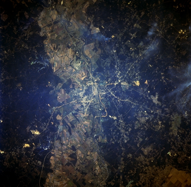 |
| STS068-256-068 Alexandria, Louisiana October 1994 A concentration of cultivated field patterns is observable on the floodplain (light-colored swath running horizontally across the image) of the Red River both southeast and northwest of Alexandria. The actual river channel is difficult to identify as it flows southeast, especially as it meanders through the built-up urban area of Alexandria. Since Alexandria is located near the center of the state, several ground transportation links including highways--Interstate Highway 49 that connects Shreveport with Lafayette--and railroad right a ways can be traced across the fairly flat landscape (generally light-colored, thin, linear features). The darker terrain is primarily forested land. Intersecting runways for the two airports can also be discriminated: England Air Force Base immediately west of the highly reflective downtown area in the center of the image, and Esler Field which is located northeast of the downtown area of Alexandria. |
| Images: | All Available Images Low-Resolution 341k |
|
| Mission: | STS068 |
|
| Roll - Frame: | 256 - 68 |
|
| Geographical Name: | USA-LOUISIANA |
|
| Features: | ALEXANDRIA AREA, RED R. |
|
| Center Lat x Lon: | 31.5N x 92.5W |
|
| Film Exposure: | N | N=Normal exposure, U=Under exposed, O=Over exposed, F=out of Focus |
| Percentage of Cloud Cover-CLDP: | 0 |
|
| Camera:: | HB |
|
| Camera Tilt: | 20 | LO=Low Oblique, HO=High Oblique, NV=Near Vertical |
| Camera Focal Length: | 250 |
|
| Nadir to Photo Center Direction: | SW | The direction from the nadir to the center point, N=North, S=South, E=East, W=West |
| Stereo?: | Y | Y=Yes there is an adjacent picture of the same area, N=No there isn't |
| Orbit Number: | 87 |
|
| Date: | 19941005 | YYYYMMDD |
| Time: | 190539 | GMT HHMMSS |
| Nadir Lat: | 31.9N |
Latitude of suborbital point of spacecraft |
| Nadir Lon: | 91.9W |
Longitude of suborbital point of spacecraft |
| Sun Azimuth: | 208 | Clockwise angle in degrees from north to the sun measured at the nadir point |
| Space Craft Altitude: | 116 | nautical miles |
| Sun Elevation: | 50 | Angle in degrees between the horizon and the sun, measured at the nadir point |
| Land Views: | PLAIN, FOREST |
|
| Water Views: | RIVER |
|
| Atmosphere Views: | SMOKE |
|
| Man Made Views: | URBAN AREA |
|
| City Views: | ALEXANDRIA |
|
Photo is not associated with any sequences | ||
| NASA Home Page |
JSC Home Page |
JSC Digital Image Collection |
Earth Science & Remote Sensing |
|
This service is provided by the International Space Station program and the JSC Earth Science & Remote Sensing Unit, ARES Division, Exploration Integration Science Directorate.

|