Geographic Region: JAPAN
Feature: KYUSHU, KITA-KYUSHU AREA
|
Geographic Region: JAPAN Feature: KYUSHU, KITA-KYUSHU AREA |
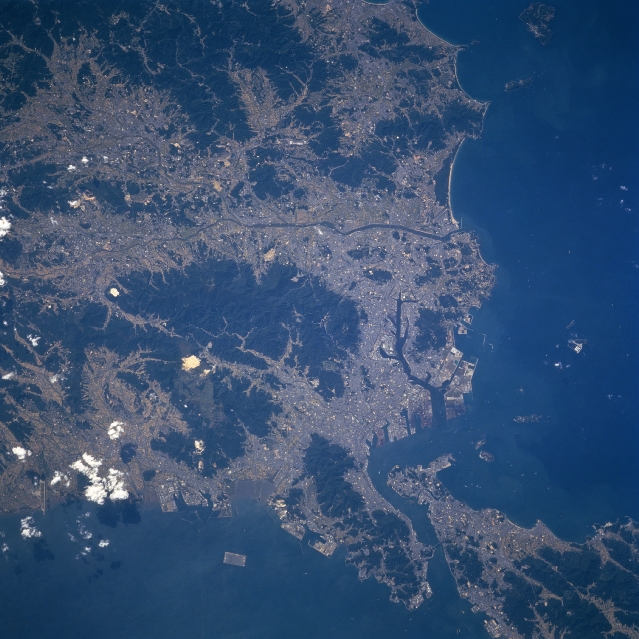 |
| STS068-253-008 Kitakyushu, Kyushu, Japan October 1994 The Shimonoseki Strait separates the southwest tip of Honshu from the northern tip of Kyushu Island (lower right), the southernmost of the four main Japanese Islands. One of Japan's major international ports, Kitakyushu, a city of over one million people, is located along the northern tip of Kyushu. Kitakyushu is connected to the city of Shimonoseki on the Honshu side of the strait by a tunnel and Kanmon bridge (near the lower right corner). The darker terrain shows the extent of the forested mountains and the lighter-colored regions show the distribution of human habitation in the river valley, the coastal lowlands, and the limited plains. These lighter areas consist of the residential, industrial, and commercial uses of the land, including limited agriculture. A variety of harbor facilities (irregular but angular patterns along the coastline) are visible, especially on the Strait of Korea side (left of the Shimonoseki Strait). The rectangular-shaped feature in the water (bottom center) west of the larger peninsula is the newly constructed Kitakyushu International Airport. |
| Images: | All Available Images Low-Resolution 348k |
|
| Mission: | STS068 |
|
| Roll - Frame: | 253 - 8 |
|
| Geographical Name: | JAPAN |
|
| Features: | KYUSHU, KITA-KYUSHU AREA |
|
| Center Lat x Lon: | 33.5N x 130.5E |
|
| Film Exposure: | N | N=Normal exposure, U=Under exposed, O=Over exposed, F=out of Focus |
| Percentage of Cloud Cover-CLDP: | 5 |
|
| Camera:: | HB |
|
| Camera Tilt: | 36 | LO=Low Oblique, HO=High Oblique, NV=Near Vertical |
| Camera Focal Length: | 250 |
|
| Nadir to Photo Center Direction: | W | The direction from the nadir to the center point, N=North, S=South, E=East, W=West |
| Stereo?: | N | Y=Yes there is an adjacent picture of the same area, N=No there isn't |
| Orbit Number: | 77 |
|
| Date: | 19941005 | YYYYMMDD |
| Time: | 041724 | GMT HHMMSS |
| Nadir Lat: | 33.8N |
Latitude of suborbital point of spacecraft |
| Nadir Lon: | 131.9E |
Longitude of suborbital point of spacecraft |
| Sun Azimuth: | 209 | Clockwise angle in degrees from north to the sun measured at the nadir point |
| Space Craft Altitude: | 117 | nautical miles |
| Sun Elevation: | 48 | Angle in degrees between the horizon and the sun, measured at the nadir point |
| Land Views: | MOUNTAIN, PLAIN |
|
| Water Views: | RIVER, STRAIT |
|
| Atmosphere Views: | |
|
| Man Made Views: | PORT |
|
| City Views: | |
|
Photo is not associated with any sequences | ||
| NASA Home Page |
JSC Home Page |
JSC Digital Image Collection |
Earth Science & Remote Sensing |
|
This service is provided by the International Space Station program and the JSC Earth Science & Remote Sensing Unit, ARES Division, Exploration Integration Science Directorate.

|