Geographic Region: JAPAN
Feature: KYUSHU, RADIAL DRAINAGE
|
Geographic Region: JAPAN Feature: KYUSHU, RADIAL DRAINAGE |
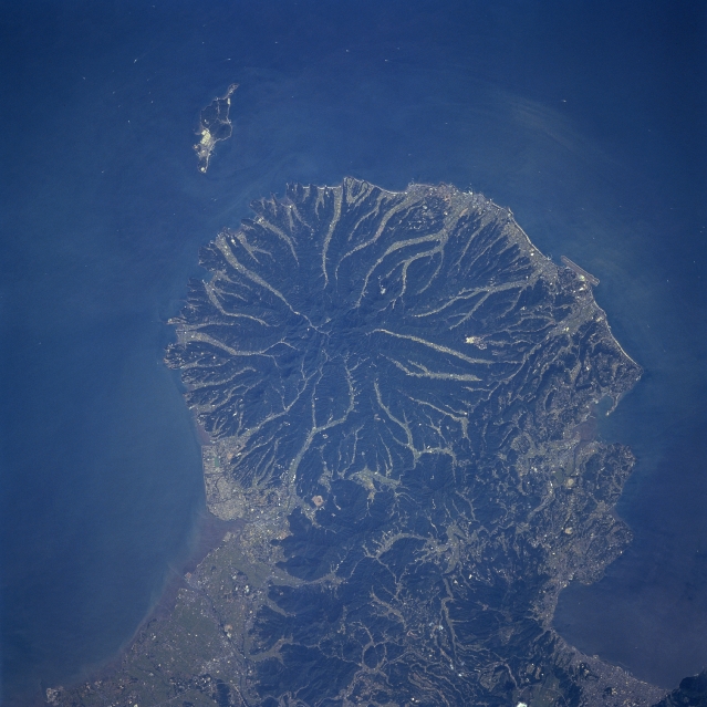 |
| STS068-253-007 Futago Mountain, Kyushu, Japan October, 1994 This detailed view of Futago Mountain (center of image), highest elevation 2365 feet (721 meters), shows a classic radial drainage pattern that is usually associated with volcanoes. The darker landscape maps the steep sloped, densely forested mountain ridgelines, while the lighter colored, linear areas show the eroded valleys that are being used for intensive agriculture. The limited areas of coastal plains are used either for urban development or intensive agriculture. Hime Island is visible off the north coast of this mountainous peninsula that juts northeasterly into the Inland Sea of Japan. |
| Images: | All Available Images Low-Resolution 299k |
|
| Mission: | STS068 |
|
| Roll - Frame: | 253 - 7 |
|
| Geographical Name: | JAPAN |
|
| Features: | KYUSHU, RADIAL DRAINAGE |
|
| Center Lat x Lon: | 33.5N x 131.5E |
|
| Film Exposure: | N | N=Normal exposure, U=Under exposed, O=Over exposed, F=out of Focus |
| Percentage of Cloud Cover-CLDP: | 0 |
|
| Camera:: | HB |
|
| Camera Tilt: | 15 | LO=Low Oblique, HO=High Oblique, NV=Near Vertical |
| Camera Focal Length: | 250 |
|
| Nadir to Photo Center Direction: | S | The direction from the nadir to the center point, N=North, S=South, E=East, W=West |
| Stereo?: | N | Y=Yes there is an adjacent picture of the same area, N=No there isn't |
| Orbit Number: | 77 |
|
| Date: | 19941005 | YYYYMMDD |
| Time: | 041719 | GMT HHMMSS |
| Nadir Lat: | 34.0N |
Latitude of suborbital point of spacecraft |
| Nadir Lon: | 131.6E |
Longitude of suborbital point of spacecraft |
| Sun Azimuth: | 208 | Clockwise angle in degrees from north to the sun measured at the nadir point |
| Space Craft Altitude: | 117 | nautical miles |
| Sun Elevation: | 48 | Angle in degrees between the horizon and the sun, measured at the nadir point |
| Land Views: | VOLCANO, FOREST, MOUNTAIN |
|
| Water Views: | SEA |
|
| Atmosphere Views: | |
|
| Man Made Views: | |
|
| City Views: | |
|
Photo is not associated with any sequences | ||
| NASA Home Page |
JSC Home Page |
JSC Digital Image Collection |
Earth Science & Remote Sensing |
|
This service is provided by the International Space Station program and the JSC Earth Science & Remote Sensing Unit, ARES Division, Exploration Integration Science Directorate.

|