
Geographic Region: USA-OKLAHOMA
Feature: LAKE TEXOMA, RED R.,SOFT
|
Geographic Region: USA-OKLAHOMA Feature: LAKE TEXOMA, RED R.,SOFT |
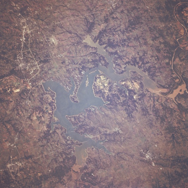 |
| STS068-247-079 Lake Texoma Area, Oklahoma and Texas, U.S.A. October 1994 This south-looking, low-oblique photograph captures Lake Texoma, created when Denison Dam was built after World War II. Located on the Red River between Oklahoma and Texas, Lake Texoma serves the surrounding region as a source of hydroelectricity, irrigation, and recreation. The Red River, the southernmost of the large tributaries of the Mississippi River, [1222 miles (1966 kilometers) long] rises in eastern New Mexico; flows across the Texas Panhandle in a southeasterly direction; turns south near Fulton, Arkansas; continues past Shreveport, the head of navigation for the Red River; and joins the Mississippi River approximately 30 miles (48 kilometers) north of Baton Rouge, Louisiana. The rich, red clay soils of the prime agricultural region around Lake Texoma can be seen in the sediment entering the lake from the west and from the north. Visible near the northeast corner of the photograph is the small city of Durant, Oklahoma, a commercial and processing center for agricultural products such as peanuts, winter wheat, cotton, and cattle. Just south of Denison Dam is the small city of Denison, Texas, birthplace of Dwight D. Eisenhower, 34th President of the United States. Industries in Denison include textile mills, garment factories, and agricultural processing plants for peanuts, grapes, pecans, and cotton. Ten miles (16 kilometers) south of Denison (observable near the southeast corner of the photograph) is the small city of Sherman, which is 60 miles (97 kilometers) north-northeast of Dallas. The runways of Perrin Air Force Base can be seen northwest of the city. Originally on a stagecoach route, the city is now a highway and railroad junction. Industries include flour and feed mills, cotton, textile factories, business machines, instruments, and surgical dressings. |
| Images: | All Available Images Low-Resolution 137k |
|
| Mission: | STS068 |
|
| Roll - Frame: | 247 - 79 |
|
| Geographical Name: | USA-OKLAHOMA |
|
| Features: | LAKE TEXOMA, RED R.,SOFT |
|
| Center Lat x Lon: | 34.0N x 96.5W |
|
| Film Exposure: | F | N=Normal exposure, U=Under exposed, O=Over exposed, F=out of Focus |
| Percentage of Cloud Cover-CLDP: | 0 |
|
| Camera:: | HB |
|
| Camera Tilt: | 28 | LO=Low Oblique, HO=High Oblique, NV=Near Vertical |
| Camera Focal Length: | 250 |
|
| Nadir to Photo Center Direction: | SW | The direction from the nadir to the center point, N=North, S=South, E=East, W=West |
| Stereo?: | N | Y=Yes there is an adjacent picture of the same area, N=No there isn't |
| Orbit Number: | 151 |
|
| Date: | 19941009 | YYYYMMDD |
| Time: | 173812 | GMT HHMMSS |
| Nadir Lat: | 34.6N |
Latitude of suborbital point of spacecraft |
| Nadir Lon: | 95.7W |
Longitude of suborbital point of spacecraft |
| Sun Azimuth: | 168 | Clockwise angle in degrees from north to the sun measured at the nadir point |
| Space Craft Altitude: | 111 | nautical miles |
| Sun Elevation: | 48 | Angle in degrees between the horizon and the sun, measured at the nadir point |
| Land Views: | PLAIN, HILL |
|
| Water Views: | LAKE, RIVER, SEDIMENT |
|
| Atmosphere Views: | |
|
| Man Made Views: | URBAN AREA, AIRPORT, AGRICULTURE, DAM |
|
| City Views: | |
|
Photo is not associated with any sequences | ||
| NASA Home Page |
JSC Home Page |
JSC Digital Image Collection |
Earth Science & Remote Sensing |
|
This service is provided by the International Space Station program and the JSC Earth Science & Remote Sensing Unit, ARES Division, Exploration Integration Science Directorate.

|