
Geographic Region:
Feature: UNFOCUSED EARTHOBS
|
Geographic Region: Feature: UNFOCUSED EARTHOBS |
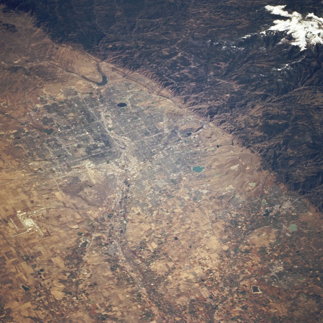 |
| STS068-247-066 Denver, Colorado, U.S.A. October 1994 This southwest-looking, low-oblique photograph shows the Front Range of the Rocky Mountains and Denver, the capital of Colorado. Denver became an important and prosperous trading center and city during the rich gold and silver strikes of the late 1870s and 1880s. With a metropolitan population of 1.8 million, Denver is a financial processing center; shipping and distributing point for an extensive agricultural area; headquarters for numerous gold, silver, and coal mining operations and sugar beet industries. Denver has stockyards and meat-packing plants; publishing houses; railroad shops; fruit and vegetable canneries; feed and flour mills; many electronics plants; and manufacturing facilities for mining machinery, aerospace, scientific apparatus, rubber goods, and luggage. Tourism is also important, especially during the long skiing season. Northeast of the central city, the runways of the new Denver International Airport are visible; just southwest of the new airport toward the central city, the runways of the old Stapleton Airport can be seen. West of the city (near the southwest edge of the photograph) 14 260-foot (4349-meter) snow-covered Mount Evans stands out dramatically. At the summit of Mount Evans is the world-famous International University Cosmic Ray Laboratory (not visible in the photograph). |
| Images: | All Available Images Low-Resolution 159k |
|
| Mission: | STS068 |
|
| Roll - Frame: | 247 - 66 |
|
| Geographical Name: | |
|
| Features: | UNFOCUSED EARTHOBS |
|
| Center Lat x Lon: | N x E |
|
| Film Exposure: | F | N=Normal exposure, U=Under exposed, O=Over exposed, F=out of Focus |
| Percentage of Cloud Cover-CLDP: | ||
| Camera:: | HB |
|
| Camera Tilt: | LO=Low Oblique, HO=High Oblique, NV=Near Vertical |
|
| Camera Focal Length: | |
|
| Nadir to Photo Center Direction: | The direction from the nadir to the center point, N=North, S=South, E=East, W=West |
|
| Stereo?: | Y=Yes there is an adjacent picture of the same area, N=No there isn't |
|
| Orbit Number: | 151 |
|
| Date: | 19941009 | YYYYMMDD |
| Time: | 173549 | GMT HHMMSS |
| Nadir Lat: | 41.6N |
Latitude of suborbital point of spacecraft |
| Nadir Lon: | 103.6W |
Longitude of suborbital point of spacecraft |
| Sun Azimuth: | 158 | Clockwise angle in degrees from north to the sun measured at the nadir point |
| Space Craft Altitude: | 111 | nautical miles |
| Sun Elevation: | 40 | Angle in degrees between the horizon and the sun, measured at the nadir point |
| Land Views: | MOUNTAIN, PLAIN |
|
| Water Views: | RIVER, LAKE |
|
| Atmosphere Views: | |
|
| Man Made Views: | URBAN AREA, AIRPORT, AGRICULTURE |
|
| City Views: | |
|
Photo is not associated with any sequences | ||
| NASA Home Page |
JSC Home Page |
JSC Digital Image Collection |
Earth Science & Remote Sensing |
|
This service is provided by the International Space Station program and the JSC Earth Science & Remote Sensing Unit, ARES Division, Exploration Integration Science Directorate.

|