Geographic Region: JAPAN
Feature: HOKKAIDO, MTS.,LAKES, CY
|
Geographic Region: JAPAN Feature: HOKKAIDO, MTS.,LAKES, CY |
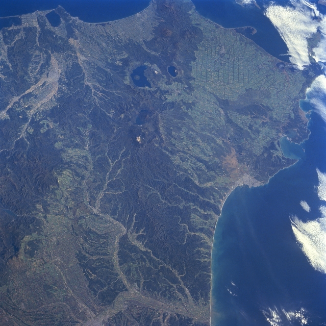 |
| STS068-245-092 Eastern Hokkaido Island, Japan October 1994 A synoptic view of the eastern end of Hokkaido Island presents a diverse landscape of plains, drainage patterns, river valleys, lakes, peninsulas, and volcanic mountains. The features include the intensively cultivated Tokachi Plains (lower left) and the broad floodplains of the Obihiro and Tokachi Rivers (lighter-colored swaths bottom center); a northeast-southwest aligned belt of volcanic mountains (dark region extending vertically through the center of the image) with water filled calderas (dark features)- Lake Kutcharoko is the lighter lake and Lake Mashuko the smaller; an extensive gridded pattern near the eastern end of the island that is related to the forestry industry; and several coastal features that include peninsulas, estuaries, bays (Akkeshi Bay- middle right) and a sand spit along the east coast that extends into Nemuro Strait. A section of the Ishikari range of volcanic mountains (darker area left center) parallels the northwest margin of the Tokachi River Basin. The dark areas show regions of dense vegetative cover, mainly forested lands. |
| Images: | All Available Images Low-Resolution 352k |
|
| Mission: | STS068 |
|
| Roll - Frame: | 245 - 92 |
|
| Geographical Name: | JAPAN |
|
| Features: | HOKKAIDO, MTS.,LAKES, CY |
|
| Center Lat x Lon: | 43.5N x 144.0E |
|
| Film Exposure: | N | N=Normal exposure, U=Under exposed, O=Over exposed, F=out of Focus |
| Percentage of Cloud Cover-CLDP: | 10 |
|
| Camera:: | HB |
|
| Camera Tilt: | 46 | LO=Low Oblique, HO=High Oblique, NV=Near Vertical |
| Camera Focal Length: | 100 |
|
| Nadir to Photo Center Direction: | E | The direction from the nadir to the center point, N=North, S=South, E=East, W=West |
| Stereo?: | Y | Y=Yes there is an adjacent picture of the same area, N=No there isn't |
| Orbit Number: | 172 |
|
| Date: | 19941011 | YYYYMMDD |
| Time: | 003519 | GMT HHMMSS |
| Nadir Lat: | 42.7N |
Latitude of suborbital point of spacecraft |
| Nadir Lon: | 142.3E |
Longitude of suborbital point of spacecraft |
| Sun Azimuth: | 148 | Clockwise angle in degrees from north to the sun measured at the nadir point |
| Space Craft Altitude: | 111 | nautical miles |
| Sun Elevation: | 35 | Angle in degrees between the horizon and the sun, measured at the nadir point |
| Land Views: | MOUNTAIN, VOLCANO, PLAIN, FOREST |
|
| Water Views: | RIVER, LAKE |
|
| Atmosphere Views: | |
|
| Man Made Views: | DEFORESTATION |
|
| City Views: | |
|
Photo is not associated with any sequences | ||
| NASA Home Page |
JSC Home Page |
JSC Digital Image Collection |
Earth Science & Remote Sensing |
|
This service is provided by the International Space Station program and the JSC Earth Science & Remote Sensing Unit, ARES Division, Exploration Integration Science Directorate.

|