
Geographic Region: PACIFIC OCEAN
Feature: CLOUD FORMATIONS,SUNGLINT
|
Geographic Region: PACIFIC OCEAN Feature: CLOUD FORMATIONS,SUNGLINT |
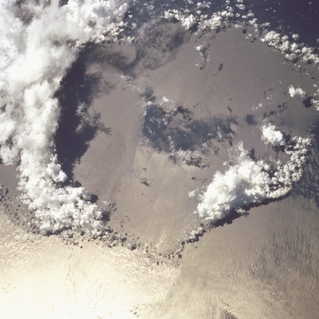 |
| STS068-244-93 Collapsed Thunderstorm, Pacific Ocean October 1994 The large circular area of a recently collapsed thunderstorm is seen in this photograph. It is located just north of the equator near the island and atolls of the Federated States of Micronesia in the Pacific Ocean. Thunderstorms form when the atmosphere is unstable and moist warm air near the surface rises. If the differential air temperature is great enough, thunderstorms can form. The moist air can penetrate into the stratosphere to altitudes of more than 12.5 miles (20 km). These types of storms can produce violent updrafts and downdrafts. At the onset of precipitation, strong downdrafts develop. Falling precipitation reverses rising air columns by frictional drag, and eventually the thunderstorm will begin to dissipate. The strong cool downdrafts will eventually clear the region. New clouds can be seen forming in the upper left of the photograph. |
| Images: | All Available Images Low-Resolution 117k |
|
| Mission: | STS068 |
|
| Roll - Frame: | 244 - 93 |
|
| Geographical Name: | PACIFIC OCEAN |
|
| Features: | CLOUD FORMATIONS,SUNGLINT |
|
| Center Lat x Lon: | N x E |
|
| Film Exposure: | N | N=Normal exposure, U=Under exposed, O=Over exposed, F=out of Focus |
| Percentage of Cloud Cover-CLDP: | 20 |
|
| Camera:: | HB |
|
| Camera Tilt: | LO | LO=Low Oblique, HO=High Oblique, NV=Near Vertical |
| Camera Focal Length: | 250 |
|
| Nadir to Photo Center Direction: | The direction from the nadir to the center point, N=North, S=South, E=East, W=West |
|
| Stereo?: | N | Y=Yes there is an adjacent picture of the same area, N=No there isn't |
| Orbit Number: | 109 |
|
| Date: | 19941007 | YYYYMMDD |
| Time: | 034649 | GMT HHMMSS |
| Nadir Lat: | 2.5N |
Latitude of suborbital point of spacecraft |
| Nadir Lon: | 152.0E |
Longitude of suborbital point of spacecraft |
| Sun Azimuth: | 256 | Clockwise angle in degrees from north to the sun measured at the nadir point |
| Space Craft Altitude: | 117 | nautical miles |
| Sun Elevation: | 57 | Angle in degrees between the horizon and the sun, measured at the nadir point |
| Land Views: | |
|
| Water Views: | OCEAN |
|
| Atmosphere Views: | THUNDERSTORM |
|
| Man Made Views: | |
|
| City Views: | |
|
Photo is not associated with any sequences | ||
| NASA Home Page |
JSC Home Page |
JSC Digital Image Collection |
Earth Science & Remote Sensing |
|
This service is provided by the International Space Station program and the JSC Earth Science & Remote Sensing Unit, ARES Division, Exploration Integration Science Directorate.

|