
Geographic Region: USA-CALIFORNIA
Feature: SACRAMENTO, RES, CANALS
|
Geographic Region: USA-CALIFORNIA Feature: SACRAMENTO, RES, CANALS |
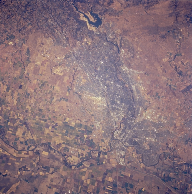 |
| STS068-244-018 Sacramento, California, U.S.A. October 1994 Sacramento, the capital of California and the western terminus of the Pony Express in the late 1850s and early 1860s, is visible in this near-vertical photograph. The city, an important transportation center for the truck farms of the rich Sacramento Valley, lies 72 miles (116 kilometers) northeast of San Francisco. Sacramento is a deepwater port via a channel that leads to Suisun Bay. Agricultural field patterns are visible on either side of the Sacramento River, the longest river in California. The American River, flowing westward from the Sierra Nevada Range through Folsum Lake, joins the Sacramento River. Major transportation arteries appear as straight white lines north of the city heading east into the foothills of the Sierra Nevadas. |
| Images: | All Available Images Low-Resolution 361k |
|
| Mission: | STS068 |
|
| Roll - Frame: | 244 - 18 |
|
| Geographical Name: | USA-CALIFORNIA |
|
| Features: | SACRAMENTO, RES, CANALS |
|
| Center Lat x Lon: | 38.5N x 121.5W |
|
| Film Exposure: | N | N=Normal exposure, U=Under exposed, O=Over exposed, F=out of Focus |
| Percentage of Cloud Cover-CLDP: | 0 |
|
| Camera:: | HB |
|
| Camera Tilt: | 31 | LO=Low Oblique, HO=High Oblique, NV=Near Vertical |
| Camera Focal Length: | 250 |
|
| Nadir to Photo Center Direction: | SE | The direction from the nadir to the center point, N=North, S=South, E=East, W=West |
| Stereo?: | Y | Y=Yes there is an adjacent picture of the same area, N=No there isn't |
| Orbit Number: | 104 |
|
| Date: | 19941006 | YYYYMMDD |
| Time: | 201155 | GMT HHMMSS |
| Nadir Lat: | 39.1N |
Latitude of suborbital point of spacecraft |
| Nadir Lon: | 122.5W |
Longitude of suborbital point of spacecraft |
| Sun Azimuth: | 185 | Clockwise angle in degrees from north to the sun measured at the nadir point |
| Space Craft Altitude: | 116 | nautical miles |
| Sun Elevation: | 46 | Angle in degrees between the horizon and the sun, measured at the nadir point |
| Land Views: | VALLEY |
|
| Water Views: | RIVER, LAKE |
|
| Atmosphere Views: | |
|
| Man Made Views: | URBAN AREA |
|
| City Views: | SACRAMENTO |
|
Photo is not associated with any sequences | ||
| NASA Home Page |
JSC Home Page |
JSC Digital Image Collection |
Earth Science & Remote Sensing |
|
This service is provided by the International Space Station program and the JSC Earth Science & Remote Sensing Unit, ARES Division, Exploration Integration Science Directorate.

|