
Geographic Region: USA-CALIFORNIA
Feature: CLEAR LAKE, COAST RANGE
|
Geographic Region: USA-CALIFORNIA Feature: CLEAR LAKE, COAST RANGE |
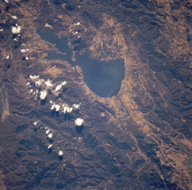 |
| STS068-244-015 Clear Lake and Coast Range, California, U.S.A. October 1994 Clear Lake, the largest freshwater lake entirely within the state of California [65 square miles (168 square kilometers)], nestles among the rugged Coast Range in this low-oblique, south-looking photograph. A popular tourist and fishing resort, Clear Lake is 25 miles (40 kilometers) long and 2 to 10 miles (3 to 16 kilometers) wide. The lake is fed at its north end by three small creeks that originate nearby in the humid Coast Range and is drained at its south end by Cache Creek, which flows southeast and empties into the Sacramento River. Mendocino National Forest is discernible in the bottom half of the photograph. |
| Images: | All Available Images Low-Resolution 370k |
|
| Mission: | STS068 |
|
| Roll - Frame: | 244 - 15 |
|
| Geographical Name: | USA-CALIFORNIA |
|
| Features: | CLEAR LAKE, COAST RANGE |
|
| Center Lat x Lon: | 39.0N x 122.5W |
|
| Film Exposure: | N | N=Normal exposure, U=Under exposed, O=Over exposed, F=out of Focus |
| Percentage of Cloud Cover-CLDP: | 5 |
|
| Camera:: | HB |
|
| Camera Tilt: | 27 | LO=Low Oblique, HO=High Oblique, NV=Near Vertical |
| Camera Focal Length: | 250 |
|
| Nadir to Photo Center Direction: | SE | The direction from the nadir to the center point, N=North, S=South, E=East, W=West |
| Stereo?: | N | Y=Yes there is an adjacent picture of the same area, N=No there isn't |
| Orbit Number: | 104 |
|
| Date: | 19941006 | YYYYMMDD |
| Time: | 201143 | GMT HHMMSS |
| Nadir Lat: | 39.7N |
Latitude of suborbital point of spacecraft |
| Nadir Lon: | 123.2W |
Longitude of suborbital point of spacecraft |
| Sun Azimuth: | 184 | Clockwise angle in degrees from north to the sun measured at the nadir point |
| Space Craft Altitude: | 116 | nautical miles |
| Sun Elevation: | 45 | Angle in degrees between the horizon and the sun, measured at the nadir point |
| Land Views: | MOUNTAIN, FOREST, FAULT |
|
| Water Views: | LAKE |
|
| Atmosphere Views: | |
|
| Man Made Views: | |
|
| City Views: | |
|
Photo is not associated with any sequences | ||
| NASA Home Page |
JSC Home Page |
JSC Digital Image Collection |
Earth Science & Remote Sensing |
|
This service is provided by the International Space Station program and the JSC Earth Science & Remote Sensing Unit, ARES Division, Exploration Integration Science Directorate.

|