
Geographic Region: USA-CALIFORNIA
Feature: EUREKA, BAY, COAST RANGE
|
Geographic Region: USA-CALIFORNIA Feature: EUREKA, BAY, COAST RANGE |
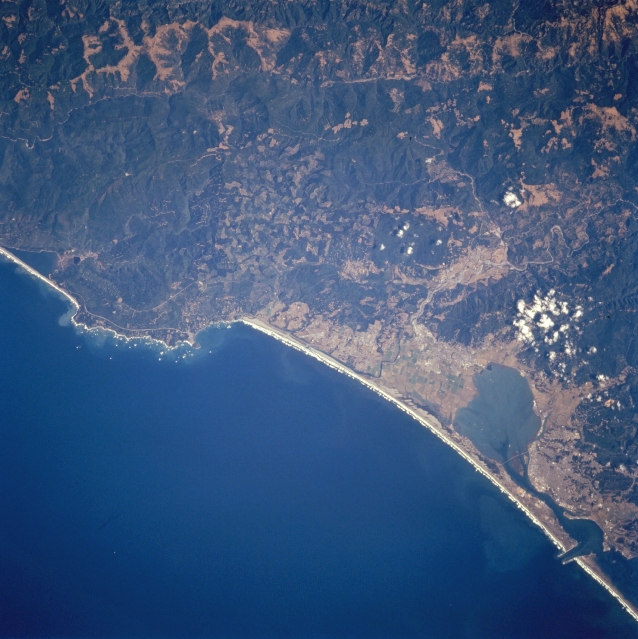 |
| STS068-244-012 Humboldt Bay and Arcata, California, U.S.A. October 1994 Humboldt Bay, an inlet of the Pacific Ocean, extends northeastward to the coastal plain city of Arcata in this near-vertical photograph. Eureka, the chief redwood outlet for the Pacific coast, lies south of Humboldt Bay. Inland from the Pacific Ocean, the rugged terrain of the forested Klamath Mountains is discernible near the center left. Trinidad Head and Rocky Point extend into the Pacific Ocean. |
| Images: | All Available Images Low-Resolution 329k |
|
| Mission: | STS068 |
|
| Roll - Frame: | 244 - 12 |
|
| Geographical Name: | USA-CALIFORNIA |
|
| Features: | EUREKA, BAY, COAST RANGE |
|
| Center Lat x Lon: | 41.0N x 124W |
|
| Film Exposure: | N | N=Normal exposure, U=Under exposed, O=Over exposed, F=out of Focus |
| Percentage of Cloud Cover-CLDP: | 5 |
|
| Camera:: | HB |
|
| Camera Tilt: | 23 | LO=Low Oblique, HO=High Oblique, NV=Near Vertical |
| Camera Focal Length: | 250 |
|
| Nadir to Photo Center Direction: | E | The direction from the nadir to the center point, N=North, S=South, E=East, W=West |
| Stereo?: | Y | Y=Yes there is an adjacent picture of the same area, N=No there isn't |
| Orbit Number: | 104 |
|
| Date: | 19941006 | YYYYMMDD |
| Time: | 201116 | GMT HHMMSS |
| Nadir Lat: | 41.0N |
Latitude of suborbital point of spacecraft |
| Nadir Lon: | 124.8W |
Longitude of suborbital point of spacecraft |
| Sun Azimuth: | 181 | Clockwise angle in degrees from north to the sun measured at the nadir point |
| Space Craft Altitude: | 115 | nautical miles |
| Sun Elevation: | 44 | Angle in degrees between the horizon and the sun, measured at the nadir point |
| Land Views: | COAST, MOUNTAIN, FOREST, FAULT |
|
| Water Views: | BAY |
|
| Atmosphere Views: | |
|
| Man Made Views: | URBAN AREA |
|
| City Views: | |
|
Photo is not associated with any sequences | ||
| NASA Home Page |
JSC Home Page |
JSC Digital Image Collection |
Earth Science & Remote Sensing |
|
This service is provided by the International Space Station program and the JSC Earth Science & Remote Sensing Unit, ARES Division, Exploration Integration Science Directorate.

|