Geographic Region: CHINA
Feature: HSIN-CH'ENG,AGR,HUANG R.
|
Geographic Region: CHINA Feature: HSIN-CH'ENG,AGR,HUANG R. |
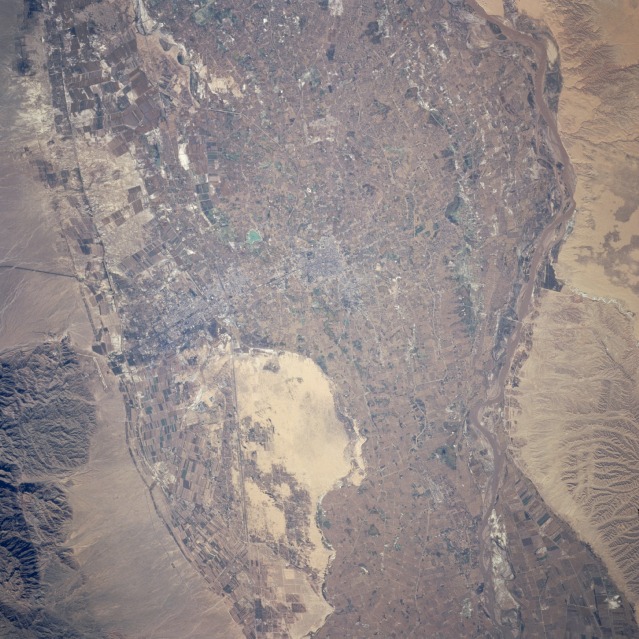 |
| STS068-239-083 Huang He (Yellow River) Agriculture, China October 1994 Modern technology and more efficient irrigation techniques have increased the agricultural productivity in many parts of arid northwest China. This detailed photograph of the cultivated field patterns that surround the towns of Yinchuan and Xincheng (center of the photograph) illustrates the effectiveness of the Chinese in transforming steppe-deserts into productive farmlands. The main crops of this region are spring wheat, sorghum, corn, and sugar beets. The tan, uncultivated, sandy area south of the towns is a reminder of the desert-like conditions that exist just beyond the irrigated floodplain of the Huang He (Yellow River). The eastern bank of the muddy north-flowing Huang He has very few cultivated fields and is characterized by an arid drainage pattern; however, the western bank displays cultivated field patterns. Several manmade features are visible in this photograph--two airport runways (one built in a north-south alignment along the eastern slope of the Helan Mountains); a north-south-oriented railroad right-of-way; and numerous roads, canals, and irrigation ditches that crisscross the floodplain. (Photograph STS-068-162-120 provides a synoptic view of this area and a more expansive view of the northern Huang He.) |
| Images: | All Available Images Low-Resolution 150k |
|
| Mission: | STS068 |
|
| Roll - Frame: | 239 - 83 |
|
| Geographical Name: | CHINA |
|
| Features: | HSIN-CH'ENG,AGR,HUANG R. |
|
| Center Lat x Lon: | 38.5N x 106.0E |
|
| Film Exposure: | N | N=Normal exposure, U=Under exposed, O=Over exposed, F=out of Focus |
| Percentage of Cloud Cover-CLDP: | 0 |
|
| Camera:: | HB |
|
| Camera Tilt: | 36 | LO=Low Oblique, HO=High Oblique, NV=Near Vertical |
| Camera Focal Length: | 250 |
|
| Nadir to Photo Center Direction: | W | The direction from the nadir to the center point, N=North, S=South, E=East, W=West |
| Stereo?: | N | Y=Yes there is an adjacent picture of the same area, N=No there isn't |
| Orbit Number: | 30 |
|
| Date: | 19941002 | YYYYMMDD |
| Time: | 064157 | GMT HHMMSS |
| Nadir Lat: | 38.4N |
Latitude of suborbital point of spacecraft |
| Nadir Lon: | 107.4E |
Longitude of suborbital point of spacecraft |
| Sun Azimuth: | 221 | Clockwise angle in degrees from north to the sun measured at the nadir point |
| Space Craft Altitude: | 118 | nautical miles |
| Sun Elevation: | 40 | Angle in degrees between the horizon and the sun, measured at the nadir point |
| Land Views: | PLAIN, MOUNTAIN, VALLEY, DESERT, HILL |
|
| Water Views: | RIVER, SEDIMENT |
|
| Atmosphere Views: | |
|
| Man Made Views: | URBAN AREA, AIRPORT, AGRICULTURE |
|
| City Views: | |
|
Photo is not associated with any sequences | ||
| NASA Home Page |
JSC Home Page |
JSC Digital Image Collection |
Earth Science & Remote Sensing |
|
This service is provided by the International Space Station program and the JSC Earth Science & Remote Sensing Unit, ARES Division, Exploration Integration Science Directorate.

|