Geographic Region: RUSSIAN FEDERATION
Feature: TULUN, IYA R., QUARRIES
|
Geographic Region: RUSSIAN FEDERATION Feature: TULUN, IYA R., QUARRIES |
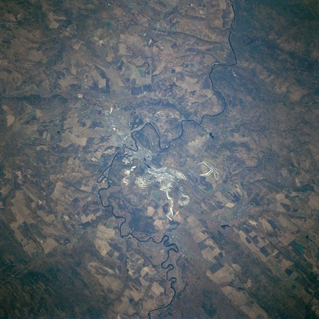 |
| STS068-239-030 Iya River, Russia October 1994 The Russian city of Tulun (left center) is situated on the north flowing Iya River (meandering, thin dark lines that runs vertically through the middle of the picture). Sections of several manmade structures including a pipeline, a highway, a power line, and a railroad are located in an east-west corridor that can be traced across the landscape in the vicinity of Tulun. The railroad is especially significant since it is part of the Trans Siberian Railroad that connects Moscow with Vladivostok, a distance of 6000 miles (9655 km). The rural area around Tulun is agrarian, where the runoff from the mountains to the south brings alluvium to enrich the soil and provides sufficient water for irrigated farming (notice the large, angular-looking, multicolored field patterns). The lighter-colored area near the center of the image but east of the Iya River, are ground scars created by the surface mining activities. |
| Images: | All Available Images Low-Resolution 375k |
|
| Mission: | STS068 |
|
| Roll - Frame: | 239 - 30 |
|
| Geographical Name: | RUSSIAN FEDERATION |
|
| Features: | TULUN, IYA R., QUARRIES |
|
| Center Lat x Lon: | 54.5N x 100.5E |
|
| Film Exposure: | N | N=Normal exposure, U=Under exposed, O=Over exposed, F=out of Focus |
| Percentage of Cloud Cover-CLDP: | 0 |
|
| Camera:: | HB |
|
| Camera Tilt: | 26 | LO=Low Oblique, HO=High Oblique, NV=Near Vertical |
| Camera Focal Length: | 250 |
|
| Nadir to Photo Center Direction: | NW | The direction from the nadir to the center point, N=North, S=South, E=East, W=West |
| Stereo?: | N | Y=Yes there is an adjacent picture of the same area, N=No there isn't |
| Orbit Number: | 29 |
|
| Date: | 19941002 | YYYYMMDD |
| Time: | 050644 | GMT HHMMSS |
| Nadir Lat: | 53.7N |
Latitude of suborbital point of spacecraft |
| Nadir Lon: | 101.0E |
Longitude of suborbital point of spacecraft |
| Sun Azimuth: | 180 | Clockwise angle in degrees from north to the sun measured at the nadir point |
| Space Craft Altitude: | 117 | nautical miles |
| Sun Elevation: | 33 | Angle in degrees between the horizon and the sun, measured at the nadir point |
| Land Views: | PLAIN |
|
| Water Views: | RIVER |
|
| Atmosphere Views: | |
|
| Man Made Views: | AGRICULTURE |
|
| City Views: | |
|
Photo is not associated with any sequences | ||
| NASA Home Page |
JSC Home Page |
JSC Digital Image Collection |
Earth Science & Remote Sensing |
|
This service is provided by the International Space Station program and the JSC Earth Science & Remote Sensing Unit, ARES Division, Exploration Integration Science Directorate.

|