
Geographic Region: USA-WASHINGTON
Feature: COLUMBIA R,L. CHELAN, MTS
|
Geographic Region: USA-WASHINGTON Feature: COLUMBIA R,L. CHELAN, MTS |
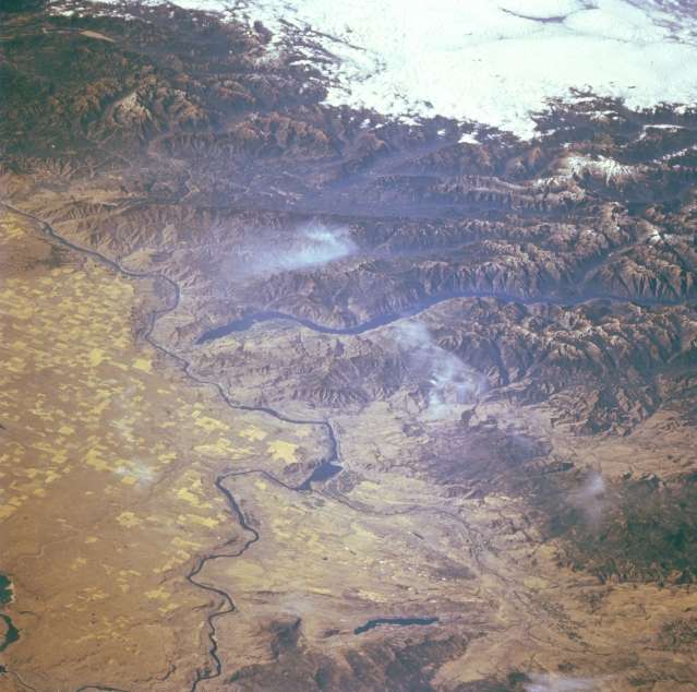 |
| STS068-237-070 Chelan Lake, Columbia River, Washington October 1994 The long snake-like blue-colored Chelan Lake, the third deepest lake in the United States, is visible near the center of the image in this southwest-looking view. Only Crater Lake and Lake Tahoe are deeper than Lake Chelan. Over 55 miles (88 km) long and slightly under I mile to 2 miles (1 to 3 km) wide, the gorge that holds Lake Chelan was carved out by a Ice Age Glaciers 20000 years ago. The southeastern end of the lake is a recreational area. Lack of roads prevents many tourists from visiting the northern end of the lake. To the west of Lake Chelan, midway between the center right and the clouds at the upper right of the image, the snow-covered 10568-foot (3223 meters) high stratovolcano Glacier Peak can be seen. The Columbia River is visible traversing the left half of the image from the bottom left to midway between the center-left to the top left of the image. Omak Lake is the small lake located near the bottom center of the image. The Okanogan River can be seen entering the image near the bottom right and flowing southward into the Columbia River at Lake Pateros. |
| Images: | All Available Images Low-Resolution 52k |
|
| Mission: | STS068 |
|
| Roll - Frame: | 237 - 70 |
|
| Geographical Name: | USA-WASHINGTON |
|
| Features: | COLUMBIA R,L. CHELAN, MTS |
|
| Center Lat x Lon: | 48.0N x 120W |
|
| Film Exposure: | N | N=Normal exposure, U=Under exposed, O=Over exposed, F=out of Focus |
| Percentage of Cloud Cover-CLDP: | 10 |
|
| Camera:: | HB |
|
| Camera Tilt: | LO | LO=Low Oblique, HO=High Oblique, NV=Near Vertical |
| Camera Focal Length: | 250 |
|
| Nadir to Photo Center Direction: | W | The direction from the nadir to the center point, N=North, S=South, E=East, W=West |
| Stereo?: | N | Y=Yes there is an adjacent picture of the same area, N=No there isn't |
| Orbit Number: | 103 |
|
| Date: | 19941006 | YYYYMMDD |
| Time: | 183922 | GMT HHMMSS |
| Nadir Lat: | 49.0N |
Latitude of suborbital point of spacecraft |
| Nadir Lon: | 115.4W |
Longitude of suborbital point of spacecraft |
| Sun Azimuth: | 165 | Clockwise angle in degrees from north to the sun measured at the nadir point |
| Space Craft Altitude: | 115 | nautical miles |
| Sun Elevation: | 35 | Angle in degrees between the horizon and the sun, measured at the nadir point |
| Land Views: | MOUNTAIN, PLATEAU, FOREST |
|
| Water Views: | RIVER, LAKE |
|
| Atmosphere Views: | |
|
| Man Made Views: | AGRICULTURE |
|
| City Views: | |
|
Photo is not associated with any sequences | ||
| NASA Home Page |
JSC Home Page |
JSC Digital Image Collection |
Earth Science & Remote Sensing |
|
This service is provided by the International Space Station program and the JSC Earth Science & Remote Sensing Unit, ARES Division, Exploration Integration Science Directorate.

|