
Geographic Region: USA-OHIO
Feature: SANDUSKY BAY,AGRICULTURE
|
Geographic Region: USA-OHIO Feature: SANDUSKY BAY,AGRICULTURE |
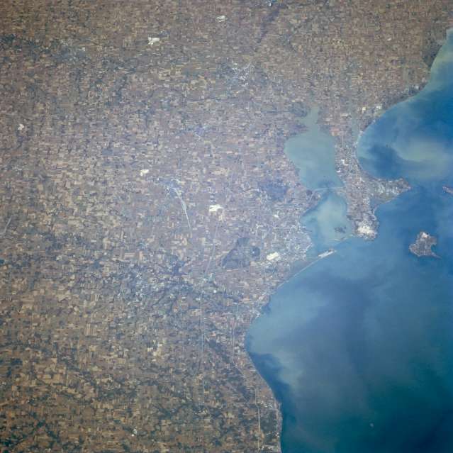 |
| STS068-237-052 Sandusky Bay; Sandusky/Norwalk, Ohio October 1994 This west-looking view shows Sandusky Bay and the agricultural land use patterns of northwest Ohio. Lake Erie, with its numerous shoreline sediment patterns, covers most of the right quarter of the image. The highly reflected white areas that are visible scattered throughout the land scene are limestone quarries, as limestone is most prevalent in northwest Ohio. The small industrial city of Sandusky, located near the outlet of Sandusky Bay (to the right of the center of the image), is discernible. To the south-southeast of Sandusky, the small city of Norwalk is visible. Rubber products are the major industry of the city of Norwalk. Kelleys Island can be seen in lake Erie at the right center of the image. |
| Images: | All Available Images Low-Resolution 48k |
|
| Mission: | STS068 |
|
| Roll - Frame: | 237 - 52 |
|
| Geographical Name: | USA-OHIO |
|
| Features: | SANDUSKY BAY,AGRICULTURE |
|
| Center Lat x Lon: | 41.5N x 83W |
|
| Film Exposure: | N | N=Normal exposure, U=Under exposed, O=Over exposed, F=out of Focus |
| Percentage of Cloud Cover-CLDP: | 0 |
|
| Camera:: | HB |
|
| Camera Tilt: | 53 | LO=Low Oblique, HO=High Oblique, NV=Near Vertical |
| Camera Focal Length: | 250 |
|
| Nadir to Photo Center Direction: | W | The direction from the nadir to the center point, N=North, S=South, E=East, W=West |
| Stereo?: | N | Y=Yes there is an adjacent picture of the same area, N=No there isn't |
| Orbit Number: | 102 |
|
| Date: | 19941006 | YYYYMMDD |
| Time: | 171335 | GMT HHMMSS |
| Nadir Lat: | 41.5N |
Latitude of suborbital point of spacecraft |
| Nadir Lon: | 80.4W |
Longitude of suborbital point of spacecraft |
| Sun Azimuth: | 181 | Clockwise angle in degrees from north to the sun measured at the nadir point |
| Space Craft Altitude: | 116 | nautical miles |
| Sun Elevation: | 43 | Angle in degrees between the horizon and the sun, measured at the nadir point |
| Land Views: | PLAIN |
|
| Water Views: | LAKE, BAY |
|
| Atmosphere Views: | |
|
| Man Made Views: | MINING, AGRICULTURE |
|
| City Views: | |
|
Photo is not associated with any sequences | ||
| NASA Home Page |
JSC Home Page |
JSC Digital Image Collection |
Earth Science & Remote Sensing |
|
This service is provided by the International Space Station program and the JSC Earth Science & Remote Sensing Unit, ARES Division, Exploration Integration Science Directorate.

|