Geographic Region: CANADA-NS
Feature: HALIFAX, NUMEROUS LAKES
|
Geographic Region: CANADA-NS Feature: HALIFAX, NUMEROUS LAKES |
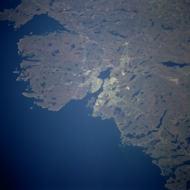 |
| STS068-236-092 Halifax, Nova Scotia, Canada October 1994 The effects of the continental ice sheet that covered the northeastern part of North America about 15 000 years ago is evident in the physical landscape surrounding the city of Halifax, Nova Scotia. The many lakes are the result of glacial scouring as the ice sheets advanced and then retreated, leaving low, water-filled areas. Most of the rural areas of the glaciated landscape are now covered by northern coniferous forests. The city of Halifax is located along the south side of Halifax Harbour. The metropolitan area including Dartmouth (the city along the northern side of Halifax Harbour), with a population of approximately 320 000, is the largest Canadian commercial center with direct access to the Atlantic Ocean. The natural harbor affords ideal drydocks, dockyards, and transshipping facilities for both imports and exports. The numerous thin, white lines radiating from the metropolitan area are highways, railroads, and power line rights-of-way extending across the forested hinterland. The runways of two major airports are visible--the T-shaped runways of Halifax International Airport approximately 15 miles (25 kilometers) north of the urban area and the runways of the Shearwater CFB (military base) east of Dartsmouth. During World War II, many ship convoys were assembled in Halifax Harbour for the transatlantic crossing. St. Margaret Bay is the large bay southwest of the Halifax area. |
| Images: | All Available Images Low-Resolution 98k |
|
| Mission: | STS068 |
|
| Roll - Frame: | 236 - 92 |
|
| Geographical Name: | CANADA-NS |
|
| Features: | HALIFAX, NUMEROUS LAKES |
|
| Center Lat x Lon: | 44.5N x 63.5W |
|
| Film Exposure: | N | N=Normal exposure, U=Under exposed, O=Over exposed, F=out of Focus |
| Percentage of Cloud Cover-CLDP: | 0 |
|
| Camera:: | HB |
|
| Camera Tilt: | 48 | LO=Low Oblique, HO=High Oblique, NV=Near Vertical |
| Camera Focal Length: | 250 |
|
| Nadir to Photo Center Direction: | W | The direction from the nadir to the center point, N=North, S=South, E=East, W=West |
| Stereo?: | N | Y=Yes there is an adjacent picture of the same area, N=No there isn't |
| Orbit Number: | 117 |
|
| Date: | 19941007 | YYYYMMDD |
| Time: | 152344 | GMT HHMMSS |
| Nadir Lat: | 43.8N |
Latitude of suborbital point of spacecraft |
| Nadir Lon: | 61.6W |
Longitude of suborbital point of spacecraft |
| Sun Azimuth: | 170 | Clockwise angle in degrees from north to the sun measured at the nadir point |
| Space Craft Altitude: | 111 | nautical miles |
| Sun Elevation: | 40 | Angle in degrees between the horizon and the sun, measured at the nadir point |
| Land Views: | COAST, HILL, FOREST, UPLAND |
|
| Water Views: | LAKE, BAY, ESTUARY |
|
| Atmosphere Views: | |
|
| Man Made Views: | URBAN AREA, AIRPORT |
|
| City Views: | HALIFAX |
|
Photo is not associated with any sequences | ||
| NASA Home Page |
JSC Home Page |
JSC Digital Image Collection |
Earth Science & Remote Sensing |
|
This service is provided by the International Space Station program and the JSC Earth Science & Remote Sensing Unit, ARES Division, Exploration Integration Science Directorate.

|