
Geographic Region: USA-COLORADO
Feature: PIKES PEAK, COL. SPRINGS
|
Geographic Region: USA-COLORADO Feature: PIKES PEAK, COL. SPRINGS |
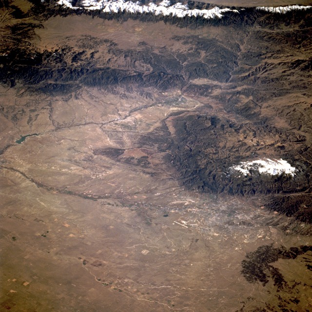 |
| STS068-235-075 Colorado Springs and Pikes Peak, Colorado, U.S.A. October 1994 Sitting at the foot of Pikes Peak, Colorado Springs [located 60 miles (100 kilometers) south of Denver] can be seen in this southwest-looking, low-oblique photograph. The city grew as a trade center for the Cripple Creek gold field in the 1870s. Pikes Peak, discovered in 1806 by Zebulun Pike, is located in the Front Range of the Rocky Mountains. The mountain is a tourist attraction noted for the view from its generally snowcapped summit, which can be reached by cog railway or highway. Colorado Springs is a beautiful residential and year-round vacation and resort city, with thriving industries producing a wide variety of products. Many mineral springs are located nearby, and the U.S. Air Force Academy is situated north-northwest of the city. Geographic features visible in the photograph are the Arkansas River Valley (south of Colorado Springs), the forest-covered Wet Mountains (southwest of Colorado Springs), and the snow-covered Sangre de Cristo Mountains (hugging the western edge of the photograph). |
| Images: | All Available Images Low-Resolution 159k |
|
| Mission: | STS068 |
|
| Roll - Frame: | 235 - 75 |
|
| Geographical Name: | USA-COLORADO |
|
| Features: | PIKES PEAK, COL. SPRINGS |
|
| Center Lat x Lon: | 38.5N x 105W |
|
| Film Exposure: | N | N=Normal exposure, U=Under exposed, O=Over exposed, F=out of Focus |
| Percentage of Cloud Cover-CLDP: | 0 |
|
| Camera:: | HB |
|
| Camera Tilt: | LO | LO=Low Oblique, HO=High Oblique, NV=Near Vertical |
| Camera Focal Length: | 250 |
|
| Nadir to Photo Center Direction: | SW | The direction from the nadir to the center point, N=North, S=South, E=East, W=West |
| Stereo?: | Y | Y=Yes there is an adjacent picture of the same area, N=No there isn't |
| Orbit Number: | 167 |
|
| Date: | 19941010 | YYYYMMDD |
| Time: | 171317 | GMT HHMMSS |
| Nadir Lat: | 40.4N |
Latitude of suborbital point of spacecraft |
| Nadir Lon: | 102.1W |
Longitude of suborbital point of spacecraft |
| Sun Azimuth: | 153 | Clockwise angle in degrees from north to the sun measured at the nadir point |
| Space Craft Altitude: | 111 | nautical miles |
| Sun Elevation: | 39 | Angle in degrees between the horizon and the sun, measured at the nadir point |
| Land Views: | MOUNTAIN, VALLEY, PLAIN, FOREST |
|
| Water Views: | RIVER |
|
| Atmosphere Views: | |
|
| Man Made Views: | URBAN AREA, AIRPORT, AGRICULTURE |
|
| City Views: | |
|
Photo is not associated with any sequences | ||
| NASA Home Page |
JSC Home Page |
JSC Digital Image Collection |
Earth Science & Remote Sensing |
|
This service is provided by the International Space Station program and the JSC Earth Science & Remote Sensing Unit, ARES Division, Exploration Integration Science Directorate.

|