Geographic Region: ARGENTINA
Feature: L VIEDMA, GLACIERS, SNOW
|
Geographic Region: ARGENTINA Feature: L VIEDMA, GLACIERS, SNOW |
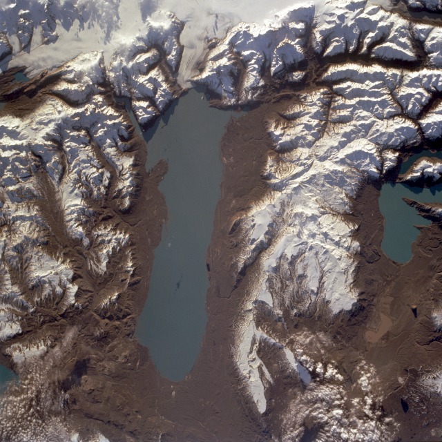 |
| STS068-234-054 Lake Viedma, Santa Cruz Province, Argentina October 1994 Lake Viedma, approximately 50 miles (80 kilometers) long in extreme southwestern Argentina, is a major elongated trough lake formed from melting glacial ice. The lake is fed primarily by the Viedma Glacier at the western end of the lake. The Viedma Glacier measures 3 miles (5 kilometers) wide at its terminus at Lake Viedma. Medial moraines, appearing as dark linear strips in the glacier, were created when adjacent ice walls from different glaciers merged. Elevations within the snow-covered southern Andes Mountains range between 9000 and 11 000 feet (2740 and 3350 meters) above sea level. Numerous features associated with the glacial environment, including hanging valleys, tarns, cirques, horns, aretes, and U-shaped valleys, are visible in this near-vertical photograph. The brown landscape resulted from ice scouring, which left virtually no vegetation on the steep-walled valleys. The blue lake near the northern edge of the photograph is a small segment of Lake San Martin. |
| Images: | All Available Images Low-Resolution 160k |
|
| Mission: | STS068 |
|
| Roll - Frame: | 234 - 54 |
|
| Geographical Name: | ARGENTINA |
|
| Features: | L VIEDMA, GLACIERS, SNOW |
|
| Center Lat x Lon: | 49.5S x 72.5W |
|
| Film Exposure: | N | N=Normal exposure, U=Under exposed, O=Over exposed, F=out of Focus |
| Percentage of Cloud Cover-CLDP: | 0 |
|
| Camera:: | HB |
|
| Camera Tilt: | 9 | LO=Low Oblique, HO=High Oblique, NV=Near Vertical |
| Camera Focal Length: | 250 |
|
| Nadir to Photo Center Direction: | S | The direction from the nadir to the center point, N=North, S=South, E=East, W=West |
| Stereo?: | Y | Y=Yes there is an adjacent picture of the same area, N=No there isn't |
| Orbit Number: | 121 |
|
| Date: | 19941007 | YYYYMMDD |
| Time: | 214724 | GMT HHMMSS |
| Nadir Lat: | 49.2S |
Latitude of suborbital point of spacecraft |
| Nadir Lon: | 72.5W |
Longitude of suborbital point of spacecraft |
| Sun Azimuth: | 276 | Clockwise angle in degrees from north to the sun measured at the nadir point |
| Space Craft Altitude: | 111 | nautical miles |
| Sun Elevation: | 13 | Angle in degrees between the horizon and the sun, measured at the nadir point |
| Land Views: | MOUNTAIN, VALLEY, GLACIER |
|
| Water Views: | LAKE |
|
| Atmosphere Views: | |
|
| Man Made Views: | |
|
| City Views: | |
|
Photo is not associated with any sequences | ||
| NASA Home Page |
JSC Home Page |
JSC Digital Image Collection |
Earth Science & Remote Sensing |
|
This service is provided by the International Space Station program and the JSC Earth Science & Remote Sensing Unit, ARES Division, Exploration Integration Science Directorate.

|