
Geographic Region: USA-MICHIGAN
Feature: DETROIT, LAKE ST. CLAIR
|
Geographic Region: USA-MICHIGAN Feature: DETROIT, LAKE ST. CLAIR |
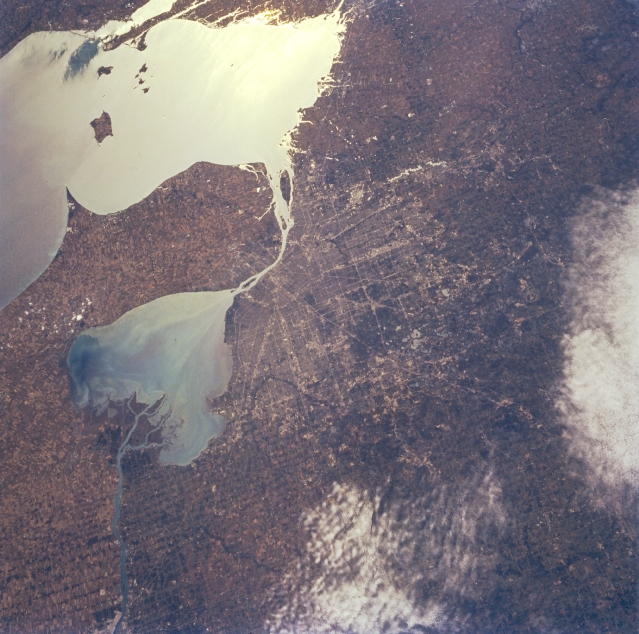 |
| STS068-232-022 Detroit, Michigan, U.S.A. October 1994 With Lake Erie in sunglint, the Detroit metropolitan area is discernible in this south-southeast-looking, low-oblique photograph. The Saint Clair River empties into Lake Saint Clair east-northeast of the city. The Detroit River drains Lake Saint Clair, flows past Detroit (west bank) and Windsor, Ontario, Canada (east bank), and empties into Lake Erie. Detroit is one of the world's major producers of automobiles and automobile parts and products. |
| Images: | All Available Images Low-Resolution 347k |
|
| Mission: | STS068 |
|
| Roll - Frame: | 232 - 22 |
|
| Geographical Name: | USA-MICHIGAN |
|
| Features: | DETROIT, LAKE ST. CLAIR |
|
| Center Lat x Lon: | 42.5N x 83W |
|
| Film Exposure: | N | N=Normal exposure, U=Under exposed, O=Over exposed, F=out of Focus |
| Percentage of Cloud Cover-CLDP: | 15 |
|
| Camera:: | HB |
|
| Camera Tilt: | 33 | LO=Low Oblique, HO=High Oblique, NV=Near Vertical |
| Camera Focal Length: | 100 |
|
| Nadir to Photo Center Direction: | S | The direction from the nadir to the center point, N=North, S=South, E=East, W=West |
| Stereo?: | N | Y=Yes there is an adjacent picture of the same area, N=No there isn't |
| Orbit Number: | 102 |
|
| Date: | 19941006 | YYYYMMDD |
| Time: | 171251 | GMT HHMMSS |
| Nadir Lat: | 43.7N |
Latitude of suborbital point of spacecraft |
| Nadir Lon: | 83.4W |
Longitude of suborbital point of spacecraft |
| Sun Azimuth: | 177 | Clockwise angle in degrees from north to the sun measured at the nadir point |
| Space Craft Altitude: | 116 | nautical miles |
| Sun Elevation: | 41 | Angle in degrees between the horizon and the sun, measured at the nadir point |
| Land Views: | |
|
| Water Views: | LAKE, DELTA, RIVER |
|
| Atmosphere Views: | |
|
| Man Made Views: | URBAN AREA |
|
| City Views: | |
|
Photo is not associated with any sequences | ||
| NASA Home Page |
JSC Home Page |
JSC Digital Image Collection |
Earth Science & Remote Sensing |
|
This service is provided by the International Space Station program and the JSC Earth Science & Remote Sensing Unit, ARES Division, Exploration Integration Science Directorate.

|