
Geographic Region: CANADA-O
Feature: THUNDER BAY, MOUNTAINS
|
Geographic Region: CANADA-O Feature: THUNDER BAY, MOUNTAINS |
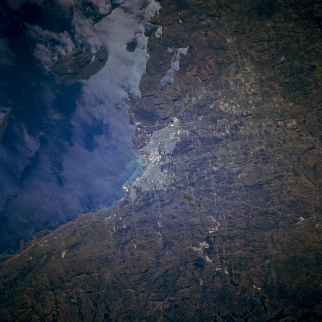 |
| STS068-230-083 Thunder Bay, Ontario, Canada October 1994 Thunder Bay, a Canadian port city along the northwest shore of Lake Superior, is visible (center of image). This image also shows a rugged, glaciated landscape, especially south of the urban area where low escarpments can be seen. Even Pie Island, southeast of the city exhibits a rough surface terrain. Cultural features include the crossing runways of Thunder Bay International Airport (southwest of built-up area); Highways 11 and 17 as well as the Thunder Bay Expressway (around the north and west side of the city); and cultivated field patterns along the Kaministikwia River Valley (west of the city). The unusual pattern on the surface waters of Lake Superior may be the result of strong surface winds. |
| Images: | All Available Images Low-Resolution 327k |
|
| Mission: | STS068 |
|
| Roll - Frame: | 230 - 83 |
|
| Geographical Name: | CANADA-O |
|
| Features: | THUNDER BAY, MOUNTAINS |
|
| Center Lat x Lon: | 48.5N x 89.5W |
|
| Film Exposure: | N | N=Normal exposure, U=Under exposed, O=Over exposed, F=out of Focus |
| Percentage of Cloud Cover-CLDP: | 0 |
|
| Camera:: | HB |
|
| Camera Tilt: | 29 | LO=Low Oblique, HO=High Oblique, NV=Near Vertical |
| Camera Focal Length: | 250 |
|
| Nadir to Photo Center Direction: | SW | The direction from the nadir to the center point, N=North, S=South, E=East, W=West |
| Stereo?: | N | Y=Yes there is an adjacent picture of the same area, N=No there isn't |
| Orbit Number: | 22 |
|
| Date: | 19941001 | YYYYMMDD |
| Time: | 184707 | GMT HHMMSS |
| Nadir Lat: | 49.3N |
Latitude of suborbital point of spacecraft |
| Nadir Lon: | 88.8W |
Longitude of suborbital point of spacecraft |
| Sun Azimuth: | 199 | Clockwise angle in degrees from north to the sun measured at the nadir point |
| Space Craft Altitude: | 117 | nautical miles |
| Sun Elevation: | 36 | Angle in degrees between the horizon and the sun, measured at the nadir point |
| Land Views: | COAST, ESCARPMENT |
|
| Water Views: | LAKE, RIVER |
|
| Atmosphere Views: | |
|
| Man Made Views: | URBAN AREA, AIRPORT, AGRICULTURE, HIGHWAY |
|
| City Views: | |
|
Photo is not associated with any sequences | ||
| NASA Home Page |
JSC Home Page |
JSC Digital Image Collection |
Earth Science & Remote Sensing |
|
This service is provided by the International Space Station program and the JSC Earth Science & Remote Sensing Unit, ARES Division, Exploration Integration Science Directorate.

|