
Geographic Region: CANADA-BC
Feature: COAST MTS., GLACIERS
|
Geographic Region: CANADA-BC Feature: COAST MTS., GLACIERS |
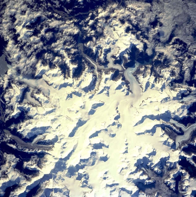 |
| STS068-230-079 Coast Mountains, British Columbia, Canada October 1994 The margins of the large ice field (white area) in the center of the picture show many valley or alpine glaciers descending from the higher elevations of this section of the Coast Mountains (Canadian-U.S. Border). The ice field straddles the Canadian-U.S. border at 57 degrees north latitude. Mt. Burkett (9730 feet - 2966 meters) and Kate's Needle (10023 feet - 3055 meters) are just two of the many ice covered peaks, known as horns, that are observed in this image. Clouds obscure the Stikine River Valley on the east side of the ice field (top of picture). |
| Images: | All Available Images Low-Resolution 400k |
|
| Mission: | STS068 |
|
| Roll - Frame: | 230 - 79 |
|
| Geographical Name: | CANADA-BC |
|
| Features: | COAST MTS., GLACIERS |
|
| Center Lat x Lon: | N x E |
|
| Film Exposure: | N | N=Normal exposure, U=Under exposed, O=Over exposed, F=out of Focus |
| Percentage of Cloud Cover-CLDP: | 20 |
|
| Camera:: | HB |
|
| Camera Tilt: | LO | LO=Low Oblique, HO=High Oblique, NV=Near Vertical |
| Camera Focal Length: | 250 |
|
| Nadir to Photo Center Direction: | The direction from the nadir to the center point, N=North, S=South, E=East, W=West |
|
| Stereo?: | Y | Y=Yes there is an adjacent picture of the same area, N=No there isn't |
| Orbit Number: | 22 |
|
| Date: | 19941001 | YYYYMMDD |
| Time: | 184020 | GMT HHMMSS |
| Nadir Lat: | 57.1N |
Latitude of suborbital point of spacecraft |
| Nadir Lon: | 131.8W |
Longitude of suborbital point of spacecraft |
| Sun Azimuth: | 147 | Clockwise angle in degrees from north to the sun measured at the nadir point |
| Space Craft Altitude: | 117 | nautical miles |
| Sun Elevation: | 25 | Angle in degrees between the horizon and the sun, measured at the nadir point |
| Land Views: | MOUNTAIN, GLACIER |
|
| Water Views: | |
|
| Atmosphere Views: | |
|
| Man Made Views: | |
|
| City Views: | |
|
Photo is not associated with any sequences | ||
| NASA Home Page |
JSC Home Page |
JSC Digital Image Collection |
Earth Science & Remote Sensing |
|
This service is provided by the International Space Station program and the JSC Earth Science & Remote Sensing Unit, ARES Division, Exploration Integration Science Directorate.

|