
Geographic Region: USA-MICHIGAN
Feature: WHITE FISH BAY,UPPER PEN
|
Geographic Region: USA-MICHIGAN Feature: WHITE FISH BAY,UPPER PEN |
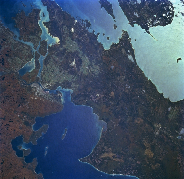 |
| STS068-229-020 Saint Marys River and Sault Sainte Marie, Michigan, U.S.A. and Canada October 1994 Part of the Saint Lawrence Seaway, sediment-laden Saint Marys River, and the Michigan and Canadian cities of Sault Sainte Marie are featured in this south-looking, low-oblique, panoramic photograph. Saint Marys River, 63 miles (101 kilometers) long, drains Whitefish Bay on Lake Superior (bottom left and center), flows past Sault Sainte Marie where it descends 20 feet (6 meters), passes Sugar Lake and Neebish Island west of Saint Joseph Island (upper left), and drains into northern Lake Huron through the De Tour Passage (not visible). Saint Marys River, part of the Canada-U.S. border and frozen for approximately 5 months of each year, is one of the world's busiest waterways with locks located near Sault Sainte Marie. The Straits of Mackinac and northern Lake Michigan are visible in sunglint (upper right). |
| Images: | All Available Images Low-Resolution 323k |
|
| Mission: | STS068 |
|
| Roll - Frame: | 229 - 20 |
|
| Geographical Name: | USA-MICHIGAN |
|
| Features: | WHITE FISH BAY,UPPER PEN |
|
| Center Lat x Lon: | 46.5N x 85W |
|
| Film Exposure: | N | N=Normal exposure, U=Under exposed, O=Over exposed, F=out of Focus |
| Percentage of Cloud Cover-CLDP: | 5 |
|
| Camera:: | HB |
|
| Camera Tilt: | LO | LO=Low Oblique, HO=High Oblique, NV=Near Vertical |
| Camera Focal Length: | 40 |
|
| Nadir to Photo Center Direction: | The direction from the nadir to the center point, N=North, S=South, E=East, W=West |
|
| Stereo?: | Y | Y=Yes there is an adjacent picture of the same area, N=No there isn't |
| Orbit Number: | |
|
| Date: | 1994____ | YYYYMMDD |
| Time: | GMT HHMMSS |
|
| Nadir Lat: | N |
Latitude of suborbital point of spacecraft |
| Nadir Lon: | E |
Longitude of suborbital point of spacecraft |
| Sun Azimuth: | Clockwise angle in degrees from north to the sun measured at the nadir point |
|
| Space Craft Altitude: | nautical miles |
|
| Sun Elevation: | Angle in degrees between the horizon and the sun, measured at the nadir point |
|
| Land Views: | FOREST, ISLAND |
|
| Water Views: | BAY, LAKE, STRAIT, RIVER |
|
| Atmosphere Views: | |
|
| Man Made Views: | URBAN AREA, AIRPORT |
|
| City Views: | |
|
Photo is not associated with any sequences | ||
| NASA Home Page |
JSC Home Page |
JSC Digital Image Collection |
Earth Science & Remote Sensing |
|
This service is provided by the International Space Station program and the JSC Earth Science & Remote Sensing Unit, ARES Division, Exploration Integration Science Directorate.

|