Geographic Region: USA-ALASKA
Feature: MALASPINA GLACIER, BANDS
|
Geographic Region: USA-ALASKA Feature: MALASPINA GLACIER, BANDS |
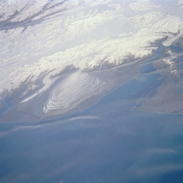 |
| STS068-227-001 Malaspina Glacier, Alaska, U.S.A. October 1994 Several alpine glaciers and Malaspina Glacier, with its lobate, concentric banks of terminal, ground, and recessional moraines, are easily discernible in this photograph. Malaspina is a classic example of a piedmont glacier that forms when valley glaciers coalesce over relatively flat land at the base of a mountain range. Immediately west of Malaspina Glacier, Agassiz Glacier curves toward Icy Bay, and to the east Hubbard Glacier flows into the northern end of Yakutat Bay. In the upper-left corner of the photograph, Logan Glacier is visible flowing westward into the Chitina River Valley. The Saint Elias Mountains north of Malaspina Glacier contain Mount Saint Elias [elevation 18 008 feet (5489 meters) above sea level] and Mount Logan [19 550 feet (5959 meters) above sea level]. The large ice field between these two peaks is Seward Glacier, which is located in the Yukon Territory of Canada. |
| Images: | All Available Images Low-Resolution 243k |
|
| Mission: | STS068 |
|
| Roll - Frame: | 227 - 1 |
|
| Geographical Name: | USA-ALASKA |
|
| Features: | MALASPINA GLACIER, BANDS |
|
| Center Lat x Lon: | 59.5N x 140.5W |
|
| Film Exposure: | N | N=Normal exposure, U=Under exposed, O=Over exposed, F=out of Focus |
| Percentage of Cloud Cover-CLDP: | 20 |
|
| Camera:: | HB |
|
| Camera Tilt: | LO | LO=Low Oblique, HO=High Oblique, NV=Near Vertical |
| Camera Focal Length: | 250 |
|
| Nadir to Photo Center Direction: | NW | The direction from the nadir to the center point, N=North, S=South, E=East, W=West |
| Stereo?: | Y | Y=Yes there is an adjacent picture of the same area, N=No there isn't |
| Orbit Number: | 23 |
|
| Date: | 19941001 | YYYYMMDD |
| Time: | 201129 | GMT HHMMSS |
| Nadir Lat: | 56.4N |
Latitude of suborbital point of spacecraft |
| Nadir Lon: | 138.1W |
Longitude of suborbital point of spacecraft |
| Sun Azimuth: | 165 | Clockwise angle in degrees from north to the sun measured at the nadir point |
| Space Craft Altitude: | 117 | nautical miles |
| Sun Elevation: | 30 | Angle in degrees between the horizon and the sun, measured at the nadir point |
| Land Views: | GLACIER, MOUNTAIN |
|
| Water Views: | BAY |
|
| Atmosphere Views: | |
|
| Man Made Views: | |
|
| City Views: | |
|
Photo is not associated with any sequences | ||
| NASA Home Page |
JSC Home Page |
JSC Digital Image Collection |
Earth Science & Remote Sensing |
|
This service is provided by the International Space Station program and the JSC Earth Science & Remote Sensing Unit, ARES Division, Exploration Integration Science Directorate.

|