Geographic Region: JAPAN
Feature: KOKKAIDO, NEMURO BAY,AGR
|
Geographic Region: JAPAN Feature: KOKKAIDO, NEMURO BAY,AGR |
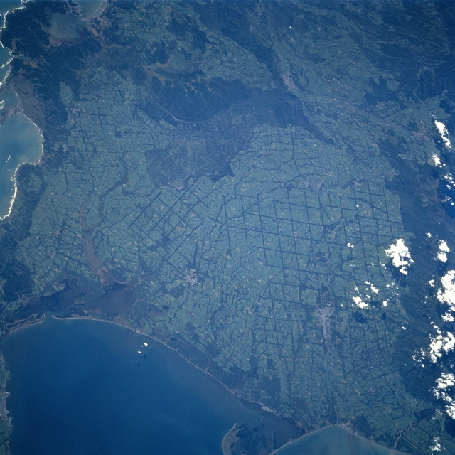 |
| STS068-214-067 Coastal Plains, Hokkaido Island, Japan October 1994 The coastal plains of east, southeast Hokkaido are visible in this generally west-looking view. The lighter colored, gridded (dark, intersecting lines) landscape, has been produced by a methodical land clearing operation, where terrain was once forested, now the land is being used for agricultural purposes. Notice that several drainage patterns can be traced across the light-colored fields. The drainage pattern shows up as dark meandering features because trees (vegetation) still outline the stream channels. A series of coastal wetlands including several estuaries and bordering swamplands (darker coastal regions) are visible. There is a large sand spit that extends eastward into the Nemuro Strait (bottom center). The darker landscapes inland are forested low-lying drainage basins or forested mountain slopes that are partially obscured by clouds (along the right edge). |
| Images: | All Available Images Low-Resolution 341k |
|
| Mission: | STS068 |
|
| Roll - Frame: | 214 - 67 |
|
| Geographical Name: | JAPAN |
|
| Features: | KOKKAIDO, NEMURO BAY,AGR |
|
| Center Lat x Lon: | 43.5N x 145.0E |
|
| Film Exposure: | N | N=Normal exposure, U=Under exposed, O=Over exposed, F=out of Focus |
| Percentage of Cloud Cover-CLDP: | 5 |
|
| Camera:: | HB |
|
| Camera Tilt: | 51 | LO=Low Oblique, HO=High Oblique, NV=Near Vertical |
| Camera Focal Length: | 250 |
|
| Nadir to Photo Center Direction: | W | The direction from the nadir to the center point, N=North, S=South, E=East, W=West |
| Stereo?: | N | Y=Yes there is an adjacent picture of the same area, N=No there isn't |
| Orbit Number: | 12 |
|
| Date: | 19941001 | YYYYMMDD |
| Time: | 040101 | GMT HHMMSS |
| Nadir Lat: | 43.3N |
Latitude of suborbital point of spacecraft |
| Nadir Lon: | 147.4E |
Longitude of suborbital point of spacecraft |
| Sun Azimuth: | 219 | Clockwise angle in degrees from north to the sun measured at the nadir point |
| Space Craft Altitude: | 118 | nautical miles |
| Sun Elevation: | 36 | Angle in degrees between the horizon and the sun, measured at the nadir point |
| Land Views: | PLAIN, MOUNTAIN, COAST |
|
| Water Views: | RIVER |
|
| Atmosphere Views: | |
|
| Man Made Views: | DEFORESTATION |
|
| City Views: | |
|
Photo is not associated with any sequences | ||
| NASA Home Page |
JSC Home Page |
JSC Digital Image Collection |
Earth Science & Remote Sensing |
|
This service is provided by the International Space Station program and the JSC Earth Science & Remote Sensing Unit, ARES Division, Exploration Integration Science Directorate.

|