
Geographic Region: USA-ARIZONA
Feature: LAS VEGAS,LAKE MEAD,MTS.
|
Geographic Region: USA-ARIZONA Feature: LAS VEGAS,LAKE MEAD,MTS. |
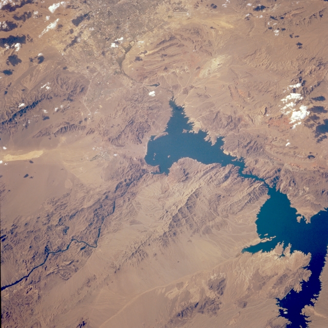 |
| STS068-214-027 Lake Mead, Nevada and Arizona, U.S.A. October 1994 Both Las Vegas and Lake Mead--southern Nevada's two major tourist attractions--are partially included in this northwest-looking photograph. Lake Mead, created by the construction of Hoover Dam (formerly Boulder Dam), is the dark body of water on the Colorado River. The very small white dot near the center of the photograph is Hoover Dam. From Hoover Dam the Colorado River begins its journey to the south, where it forms the boundary between Arizona and Nevada. Major features in this photograph include the McCullough Range south of Las Vegas; the Eldorado Mountains and Black Mountains, west and east of the Colorado River, respectively; and the Muddy Mountains northeast of Las Vegas. Although no detail of the city's infrastructure is discernible, the southeast section of Las Vegas is visible at the top of the photograph. |
| Images: | All Available Images Low-Resolution 336k |
|
| Mission: | STS068 |
|
| Roll - Frame: | 214 - 27 |
|
| Geographical Name: | USA-ARIZONA |
|
| Features: | LAS VEGAS,LAKE MEAD,MTS. |
|
| Center Lat x Lon: | 36.0N x 114.5W |
|
| Film Exposure: | N | N=Normal exposure, U=Under exposed, O=Over exposed, F=out of Focus |
| Percentage of Cloud Cover-CLDP: | 5 |
|
| Camera:: | HB |
|
| Camera Tilt: | 36 | LO=Low Oblique, HO=High Oblique, NV=Near Vertical |
| Camera Focal Length: | 250 |
|
| Nadir to Photo Center Direction: | W | The direction from the nadir to the center point, N=North, S=South, E=East, W=West |
| Stereo?: | Y | Y=Yes there is an adjacent picture of the same area, N=No there isn't |
| Orbit Number: | 8 |
|
| Date: | 19940930 | YYYYMMDD |
| Time: | 220815 | GMT HHMMSS |
| Nadir Lat: | 35.7N |
Latitude of suborbital point of spacecraft |
| Nadir Lon: | 113.1W |
Longitude of suborbital point of spacecraft |
| Sun Azimuth: | 234 | Clockwise angle in degrees from north to the sun measured at the nadir point |
| Space Craft Altitude: | 118 | nautical miles |
| Sun Elevation: | 35 | Angle in degrees between the horizon and the sun, measured at the nadir point |
| Land Views: | MOUNTAIN, DESERT |
|
| Water Views: | LAKE, RIVER |
|
| Atmosphere Views: | |
|
| Man Made Views: | DAM, URBAN AREA |
|
| City Views: | |
|
Photo is not associated with any sequences | ||
| NASA Home Page |
JSC Home Page |
JSC Digital Image Collection |
Earth Science & Remote Sensing |
|
This service is provided by the International Space Station program and the JSC Earth Science & Remote Sensing Unit, ARES Division, Exploration Integration Science Directorate.

|