
Geographic Region: USA-MICHIGAN
Feature: MINES, ST. MARYS RIVER
|
Geographic Region: USA-MICHIGAN Feature: MINES, ST. MARYS RIVER |
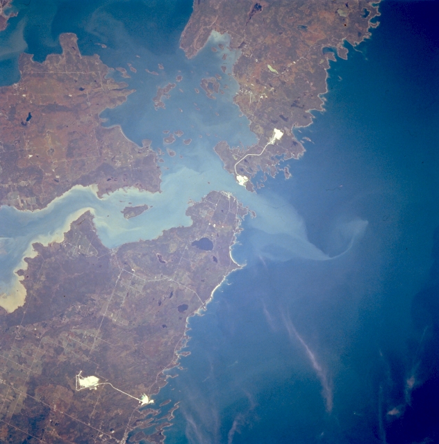 |
| STS068-212-034 De Tour Passage, Michigan, U.S.A. October 1994 Sediment-laden Saint Marys River and the De Tour Passage into northern Lake Huron, important links in the Saint Lawrence Seaway, are featured in this northeast-looking, low-oblique photograph. Two large islands are discernible--Drummond Island (right top) and Saint Joseph Island in Canada (left center). Two highly reflective objects are probably locations of mining operations. Small Caribou Lake is apparent west of the De Tour Passage. |
| Images: | All Available Images Low-Resolution 293k |
|
| Mission: | STS068 |
|
| Roll - Frame: | 212 - 34 |
|
| Geographical Name: | USA-MICHIGAN |
|
| Features: | MINES, ST. MARYS RIVER |
|
| Center Lat x Lon: | 46.0N x 84W |
|
| Film Exposure: | N | N=Normal exposure, U=Under exposed, O=Over exposed, F=out of Focus |
| Percentage of Cloud Cover-CLDP: | 5 |
|
| Camera:: | HB |
|
| Camera Tilt: | 28 | LO=Low Oblique, HO=High Oblique, NV=Near Vertical |
| Camera Focal Length: | 250 |
|
| Nadir to Photo Center Direction: | W | The direction from the nadir to the center point, N=North, S=South, E=East, W=West |
| Stereo?: | Y | Y=Yes there is an adjacent picture of the same area, N=No there isn't |
| Orbit Number: | 38 |
|
| Date: | 19941002 | YYYYMMDD |
| Time: | 183000 | GMT HHMMSS |
| Nadir Lat: | 45.7N |
Latitude of suborbital point of spacecraft |
| Nadir Lon: | 83W |
Longitude of suborbital point of spacecraft |
| Sun Azimuth: | 202 | Clockwise angle in degrees from north to the sun measured at the nadir point |
| Space Craft Altitude: | 118 | nautical miles |
| Sun Elevation: | 39 | Angle in degrees between the horizon and the sun, measured at the nadir point |
| Land Views: | FOREST |
|
| Water Views: | RIVER, SEDIMENT, LAKE |
|
| Atmosphere Views: | |
|
| Man Made Views: | MINING |
|
| City Views: | |
|
Photo is not associated with any sequences | ||
| NASA Home Page |
JSC Home Page |
JSC Digital Image Collection |
Earth Science & Remote Sensing |
|
This service is provided by the International Space Station program and the JSC Earth Science & Remote Sensing Unit, ARES Division, Exploration Integration Science Directorate.

|