
Geographic Region: ROMANIA
Feature: CARPATHIAN MTS., RIVERS
|
Geographic Region: ROMANIA Feature: CARPATHIAN MTS., RIVERS |
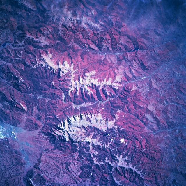 |
| STS068-211-080 Carpathian Mountains, Romania October, 1994 The southern arm of the Carpathian Mountain chain that extends through central Romania is known as the Transylvanian Alps. Snow cover (white areas) on the higher elevations, generally exceeding 5000 feet (1524 meters) above sea level, helps to accentuate the ice-formed peaks and ridgelines of this range of mountains, specifically located between Brasov (north) and Ploiesti (south). Numerous tributary stream valleys have created a rugged topography. Notice that most of the drainage from the Transylvanian Alps is towards the south and southeast. The deeper red colors indicate extensive forested terrain (green vegetation is recorded as shades of red on color infrared photography) on the steep mountain slopes. Lighter reds show areas where forest cover is less dense or the trees have been removed. The gray-looking swath of land (near bottom left corner) is an intermontane valley west of Brasov. Immediately south of the valley the highest peak (8222 feet-2506 meters) in the scene is visible near the north end of the mountain range (bottom center). |
| Images: | All Available Images Low-Resolution 411k |
|
| Mission: | STS068 |
|
| Roll - Frame: | 211 - 80 |
|
| Geographical Name: | ROMANIA |
|
| Features: | CARPATHIAN MTS., RIVERS |
|
| Center Lat x Lon: | N x E |
|
| Film Exposure: | N | N=Normal exposure, U=Under exposed, O=Over exposed, F=out of Focus |
| Percentage of Cloud Cover-CLDP: | 5 |
|
| Camera:: | HB |
|
| Camera Tilt: | LO | LO=Low Oblique, HO=High Oblique, NV=Near Vertical |
| Camera Focal Length: | 250 |
|
| Nadir to Photo Center Direction: | The direction from the nadir to the center point, N=North, S=South, E=East, W=West |
|
| Stereo?: | N | Y=Yes there is an adjacent picture of the same area, N=No there isn't |
| Orbit Number: | 177 |
|
| Date: | 19941011 | YYYYMMDD |
| Time: | 075723 | GMT HHMMSS |
| Nadir Lat: | 44.9N |
Latitude of suborbital point of spacecraft |
| Nadir Lon: | 26.5E |
Longitude of suborbital point of spacecraft |
| Sun Azimuth: | 143 | Clockwise angle in degrees from north to the sun measured at the nadir point |
| Space Craft Altitude: | 110 | nautical miles |
| Sun Elevation: | 31 | Angle in degrees between the horizon and the sun, measured at the nadir point |
| Land Views: | MOUNTAIN, VALLEY, FOREST |
|
| Water Views: | RIVER |
|
| Atmosphere Views: | |
|
| Man Made Views: | |
|
| City Views: | |
|
Photo is not associated with any sequences | ||
| NASA Home Page |
JSC Home Page |
JSC Digital Image Collection |
Earth Science & Remote Sensing |
|
This service is provided by the International Space Station program and the JSC Earth Science & Remote Sensing Unit, ARES Division, Exploration Integration Science Directorate.

|