
Geographic Region: USA
Feature: RIVERS, AGRICULTURE, MTS
|
Geographic Region: USA Feature: RIVERS, AGRICULTURE, MTS |
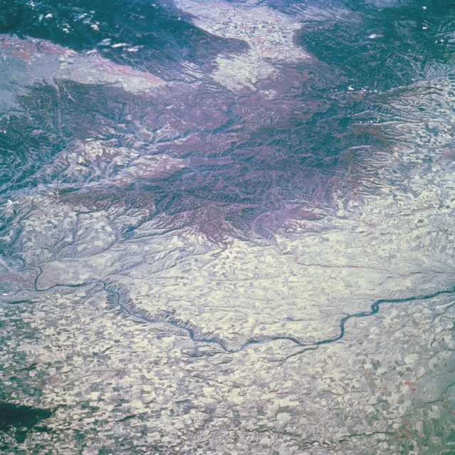 |
| STS068-209-077 Snake River, Blue Mountains, Oregon October 1994 The canyons of the Snake River, cutting its way across the Columbia Plateau and the forested (darker red color) Blue Mountains can be seen in this south-looking color infrared view. The Snake River traverses the image from near the left center at Lewiston, Idaho to near the right center of the image just before joining the Columbia River near Kennewick, Washington. Agricultural field patterns cover both sides of the Snake River in this wheat-growing region of southeastern Washington. The Blue Mountains, which are generally rounded and rugged, average 6500 feet (2000 meters) in elevation. Besides the growing of grains, stock grazing, lumbering, and mining are carried on in the vicinity of the Blue Mountains. |
| Images: | All Available Images Low-Resolution 392k |
|
| Mission: | STS068 |
|
| Roll - Frame: | 209 - 77 |
|
| Geographical Name: | USA |
|
| Features: | RIVERS, AGRICULTURE, MTS |
|
| Center Lat x Lon: | N x E |
|
| Film Exposure: | N | N=Normal exposure, U=Under exposed, O=Over exposed, F=out of Focus |
| Percentage of Cloud Cover-CLDP: | 5 |
|
| Camera:: | HB |
|
| Camera Tilt: | LO | LO=Low Oblique, HO=High Oblique, NV=Near Vertical |
| Camera Focal Length: | 250 |
|
| Nadir to Photo Center Direction: | The direction from the nadir to the center point, N=North, S=South, E=East, W=West |
|
| Stereo?: | Y | Y=Yes there is an adjacent picture of the same area, N=No there isn't |
| Orbit Number: | 103 |
|
| Date: | 19941006 | YYYYMMDD |
| Time: | 183914 | GMT HHMMSS |
| Nadir Lat: | 49.5N |
Latitude of suborbital point of spacecraft |
| Nadir Lon: | 116.5W |
Longitude of suborbital point of spacecraft |
| Sun Azimuth: | 163 | Clockwise angle in degrees from north to the sun measured at the nadir point |
| Space Craft Altitude: | 115 | nautical miles |
| Sun Elevation: | 34 | Angle in degrees between the horizon and the sun, measured at the nadir point |
| Land Views: | MOUNTAIN, PLATEAU, FOREST |
|
| Water Views: | RIVER |
|
| Atmosphere Views: | |
|
| Man Made Views: | AGRICULTURE |
|
| City Views: | |
|
Photo is not associated with any sequences | ||
| NASA Home Page |
JSC Home Page |
JSC Digital Image Collection |
Earth Science & Remote Sensing |
|
This service is provided by the International Space Station program and the JSC Earth Science & Remote Sensing Unit, ARES Division, Exploration Integration Science Directorate.

|