
Geographic Region: USA-WASHINGTON
Feature: L. CHELAN, COLUMBIA R,MTS
|
Geographic Region: USA-WASHINGTON Feature: L. CHELAN, COLUMBIA R,MTS |
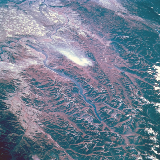 |
| STS068-209-076 Lake Chelan, Washington, U.S.A. October 1994 Lake Chelan in the northeastern Cascades is featured in this south-looking, low-oblique, infrared photograph. Lake Chelan is the third deepest lake in the United States [1486 feet (453 meters)]--only Crater Lake and Lake Tahoe are deeper. Carved by ice-age glaciers that dammed the basin that holds it, Lake Chelan is 55 miles (88 kilometers) long and approximately 1 to 2 miles (1 to 3 kilometers) wide. Its northern end is part of Lake Chelan National Recreational Area, and national forest lands extend over almost the entire length of the lake (Okanogan National Forest to its north, and Wenatchee National Forest to its south). Agricultural field patterns and the Columbia River are visible in the upper-left portion of the photograph. |
| Images: | All Available Images Low-Resolution 401k |
|
| Mission: | STS068 |
|
| Roll - Frame: | 209 - 76 |
|
| Geographical Name: | USA-WASHINGTON |
|
| Features: | L. CHELAN, COLUMBIA R,MTS |
|
| Center Lat x Lon: | 48.0N x 120.5W |
|
| Film Exposure: | N | N=Normal exposure, U=Under exposed, O=Over exposed, F=out of Focus |
| Percentage of Cloud Cover-CLDP: | 5 |
|
| Camera:: | HB |
|
| Camera Tilt: | LO | LO=Low Oblique, HO=High Oblique, NV=Near Vertical |
| Camera Focal Length: | 250 |
|
| Nadir to Photo Center Direction: | S | The direction from the nadir to the center point, N=North, S=South, E=East, W=West |
| Stereo?: | N | Y=Yes there is an adjacent picture of the same area, N=No there isn't |
| Orbit Number: | 103 |
|
| Date: | 19941006 | YYYYMMDD |
| Time: | 183833 | GMT HHMMSS |
| Nadir Lat: | 51.0N |
Latitude of suborbital point of spacecraft |
| Nadir Lon: | 120W |
Longitude of suborbital point of spacecraft |
| Sun Azimuth: | 159 | Clockwise angle in degrees from north to the sun measured at the nadir point |
| Space Craft Altitude: | 115 | nautical miles |
| Sun Elevation: | 32 | Angle in degrees between the horizon and the sun, measured at the nadir point |
| Land Views: | MOUNTAIN, FOREST |
|
| Water Views: | LAKE |
|
| Atmosphere Views: | |
|
| Man Made Views: | |
|
| City Views: | |
|
Photo is not associated with any sequences | ||
| NASA Home Page |
JSC Home Page |
JSC Digital Image Collection |
Earth Science & Remote Sensing |
|
This service is provided by the International Space Station program and the JSC Earth Science & Remote Sensing Unit, ARES Division, Exploration Integration Science Directorate.

|