
Geographic Region: USA-MARYLAND
Feature: CHEASPEAKE B.,POTOMAC R.
|
Geographic Region: USA-MARYLAND Feature: CHEASPEAKE B.,POTOMAC R. |
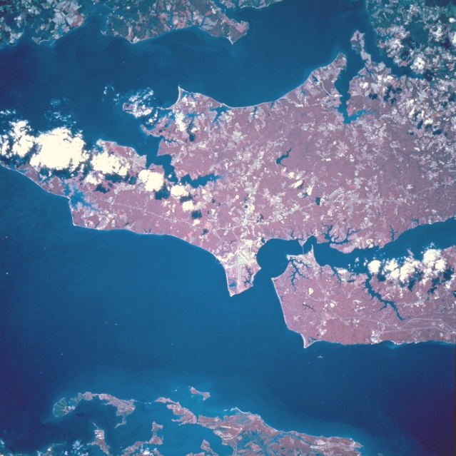 |
| STS068-209-074 Patuxent Naval Air Station, Maryland, U.S.A. October 1994 The forested, gently rolling region of southeastern Maryland is visible in this color-infrared, south-southwest-looking, low-oblique view. The runways of the Patuxent Naval Air Center are visible near the center of the image. The Air Center is home to numerous squadrons of the U. S. Navy's Atlantic Command and is also a testing center for new and modified aircraft. Chesapeake Bay, the largest estuary in the United States, covers the bottom portion of the image. To the right (northeast) of the naval air station is the Patuxent River, which exits the scene at the right center of the image. Covering most of the upper portion of the scene is the Potomac River. The extreme upper portion of the image shows the shoreline of the state of Virginia. |
| Images: | All Available Images Low-Resolution 328k |
|
| Mission: | STS068 |
|
| Roll - Frame: | 209 - 74 |
|
| Geographical Name: | USA-MARYLAND |
|
| Features: | CHEASPEAKE B.,POTOMAC R. |
|
| Center Lat x Lon: | 38.5N x 76.5W |
|
| Film Exposure: | N | N=Normal exposure, U=Under exposed, O=Over exposed, F=out of Focus |
| Percentage of Cloud Cover-CLDP: | 5 |
|
| Camera:: | HB |
|
| Camera Tilt: | 6 | LO=Low Oblique, HO=High Oblique, NV=Near Vertical |
| Camera Focal Length: | 250 |
|
| Nadir to Photo Center Direction: | N | The direction from the nadir to the center point, N=North, S=South, E=East, W=West |
| Stereo?: | N | Y=Yes there is an adjacent picture of the same area, N=No there isn't |
| Orbit Number: | 102 |
|
| Date: | 19941006 | YYYYMMDD |
| Time: | 171447 | GMT HHMMSS |
| Nadir Lat: | 38.3N |
Latitude of suborbital point of spacecraft |
| Nadir Lon: | 76.5W |
Longitude of suborbital point of spacecraft |
| Sun Azimuth: | 187 | Clockwise angle in degrees from north to the sun measured at the nadir point |
| Space Craft Altitude: | 116 | nautical miles |
| Sun Elevation: | 46 | Angle in degrees between the horizon and the sun, measured at the nadir point |
| Land Views: | FOREST |
|
| Water Views: | BAY, RIVER |
|
| Atmosphere Views: | |
|
| Man Made Views: | AIRPORT |
|
| City Views: | |
|
Photo is not associated with any sequences | ||
| NASA Home Page |
JSC Home Page |
JSC Digital Image Collection |
Earth Science & Remote Sensing |
|
This service is provided by the International Space Station program and the JSC Earth Science & Remote Sensing Unit, ARES Division, Exploration Integration Science Directorate.

|