
Geographic Region: USA-MICHIGAN
Feature: STRAITS OF MACKINAC, BRIDGE, LAKES
|
Geographic Region: USA-MICHIGAN Feature: STRAITS OF MACKINAC, BRIDGE, LAKES |
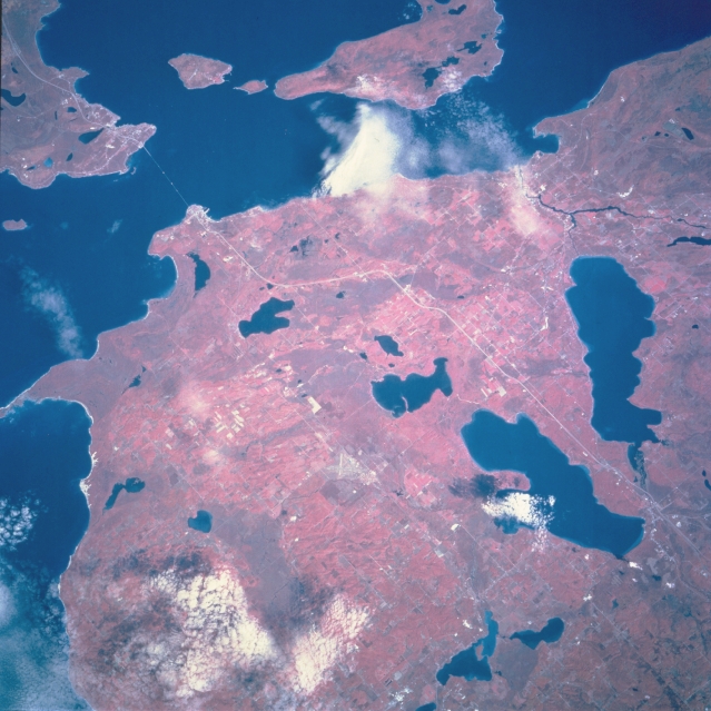 |
| STS068-209-067 Straits of Mackinac, Michigan, U.S.A. October 1994 Apparent in this northeast-looking, low-oblique, color infrared photograph are northern lower Michigan and the Straits of Mackinac, a passage between the Upper Peninsula and lower Michigan and an important link in the Saint Lawrence Seaway. The Mackinac Straits Bridge, the third longest suspension bridge in the world [3800 feet (1159 meters) long], opened in 1957 and connects Saint Ignace and Mackinaw City. East of the bridge (near top center) are Mackinac Island, a popular tourist and resort area, and larger Bois Blanc Island. North-south-oriented Interstate Highway 75 passes between Mullett Lake to the east and Burt Lake to the west, just north of which is smaller Douglas Lake. This part of northern Michigan is an agricultural area and has commercial fishing, limestone quarrying, and lumbering. The region is a popular year-round resort and recreational area. |
| Images: | All Available Images Low-Resolution 329k |
|
| Mission: | STS068 |
|
| Roll - Frame: | 209 - 67 |
|
| Geographical Name: | USA-MICHIGAN |
|
| Features: | STRAITS OF MACKINAC, BRIDGE, LAKES |
|
| Center Lat x Lon: | 45.5N x 84.5W |
|
| Film Exposure: | N | N=Normal exposure, U=Under exposed, O=Over exposed, F=out of Focus |
| Percentage of Cloud Cover-CLDP: | 10 |
|
| Camera:: | HB |
|
| Camera Tilt: | 27 | LO=Low Oblique, HO=High Oblique, NV=Near Vertical |
| Camera Focal Length: | 250 |
|
| Nadir to Photo Center Direction: | NE | The direction from the nadir to the center point, N=North, S=South, E=East, W=West |
| Stereo?: | N | Y=Yes there is an adjacent picture of the same area, N=No there isn't |
| Orbit Number: | 102 |
|
| Date: | 19941006 | YYYYMMDD |
| Time: | 171225 | GMT HHMMSS |
| Nadir Lat: | 44.9N |
Latitude of suborbital point of spacecraft |
| Nadir Lon: | 85.3W |
Longitude of suborbital point of spacecraft |
| Sun Azimuth: | 175 | Clockwise angle in degrees from north to the sun measured at the nadir point |
| Space Craft Altitude: | 116 | nautical miles |
| Sun Elevation: | 40 | Angle in degrees between the horizon and the sun, measured at the nadir point |
| Land Views: | FOREST, ISLAND |
|
| Water Views: | LAKE, STRAIT |
|
| Atmosphere Views: | |
|
| Man Made Views: | |
|
| City Views: | |
|
Photo is not associated with any sequences | ||
| NASA Home Page |
JSC Home Page |
JSC Digital Image Collection |
Earth Science & Remote Sensing |
|
This service is provided by the International Space Station program and the JSC Earth Science & Remote Sensing Unit, ARES Division, Exploration Integration Science Directorate.

|