
Geographic Region: FRANCE
Feature: LOIRE RIVER, AGRICULTURE
|
Geographic Region: FRANCE Feature: LOIRE RIVER, AGRICULTURE |
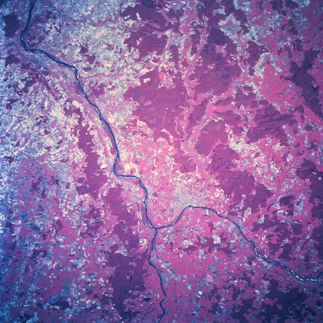 |
| STS068-209-024 Loire River, France October, 1994 A section of the Loire River Valley (dark, linear feature that extends diagonally across the color infrared image) that flows generally northwest through the northern edge of the Central Plateau of France is visible. The Allier River, the only tributary in the Loire Basin that once afforded spawning grounds for Atlantic salmon but has been affected by two dams, is also visible (bottom center). The dams, located further upstream, have been recently removed in hopes that a thriving salmon population can be reestablished in this part of the Loire River Basin. The Allier and Loire Rivers are located in rift valleys. Nevers (light-colored area, slightly below center of the image), noted for its fine artistic earthenware (china) and the largest city in Burgundy, is located 4 miles (6 km) east of the confluence of the Loire and Allier Rivers. The uniform-looking, deep reddish terrain shows the distribution of the hilly, forested (green vegetation) in this region of central France; while the lighter-colored landscape is used for grazing (mainly sheep) and the production of hardy cereal grains. |
| Images: | All Available Images Low-Resolution 425k |
|
| Mission: | STS068 |
|
| Roll - Frame: | 209 - 24 |
|
| Geographical Name: | FRANCE |
|
| Features: | LOIRE RIVER, AGRICULTURE |
|
| Center Lat x Lon: | 47.5N x 3.0E |
|
| Film Exposure: | N | N=Normal exposure, U=Under exposed, O=Over exposed, F=out of Focus |
| Percentage of Cloud Cover-CLDP: | 0 |
|
| Camera:: | HB |
|
| Camera Tilt: | 36 | LO=Low Oblique, HO=High Oblique, NV=Near Vertical |
| Camera Focal Length: | 250 |
|
| Nadir to Photo Center Direction: | N | The direction from the nadir to the center point, N=North, S=South, E=East, W=West |
| Stereo?: | Y | Y=Yes there is an adjacent picture of the same area, N=No there isn't |
| Orbit Number: | 98 |
|
| Date: | 19941006 | YYYYMMDD |
| Time: | 111700 | GMT HHMMSS |
| Nadir Lat: | 46.1N |
Latitude of suborbital point of spacecraft |
| Nadir Lon: | 3.0E |
Longitude of suborbital point of spacecraft |
| Sun Azimuth: | 174 | Clockwise angle in degrees from north to the sun measured at the nadir point |
| Space Craft Altitude: | 115 | nautical miles |
| Sun Elevation: | 39 | Angle in degrees between the horizon and the sun, measured at the nadir point |
| Land Views: | FOREST |
|
| Water Views: | RIVER |
|
| Atmosphere Views: | |
|
| Man Made Views: | AGRICULTURE |
|
| City Views: | |
|
Photo is not associated with any sequences | ||
| NASA Home Page |
JSC Home Page |
JSC Digital Image Collection |
Earth Science & Remote Sensing |
|
This service is provided by the International Space Station program and the JSC Earth Science & Remote Sensing Unit, ARES Division, Exploration Integration Science Directorate.

|